Attention
This documentation refers to the single-user TOAST-legacy version which is being phased out!
Consult https://docs.gempa.de/toast-client/current/ for the online documentation of the new TOAST multi-user version.
Save displacements
Observed displacements can be saved to an XML file via .
Note that they are stored as displacement objects and not amplitudes, and thus can not be re-imported in TOAST.
Create warning bulletins and other output using templates
Bulletin templates
TOAST provides the possibility for creating and disseminating tsunami bulletins whose content is based on data related to an incident (like earthquake origin), to one or several simulations (like forecast zones warning level) or tide gauge observations. Bulletins are generated using so-called templates.
You can disseminate a bulletin in following ways:
Hint
The Disseminate button can be renamed using
liveTab.$name.buttonText. Technically, clicking the button
executes the ClearSilver functions save and
addScript.
Note
If confirmationRequired is set, then after clicking the
Disseminate button and before the external scripts in the templates are
executed, the additional dialog: “Do you really want to continue?” pops up.
Various output formats are possible, such as HTML, XML, images or video files. Bulletins can be disseminated via channels as needed, like: text message, e-mail, video stream and other. The format and action related to an export is based on templates whose design is described in detail in ClearSilver template syntax and the configuration in Templates configuration. Live tabs allow the display and dissemination (export) of associated templates and appear as additional tabs in the Main panel.
General scheme
Templates can be defined and registered using scconfig. They point to a file that describes the region for which the template is active and to a file which contains the actual code of the template. Live tabs also have to be defined and registered. They can be associated with one or several templates.
Note
The sorting of the arrival table in a bulletin depends on the sorting of the Arrivals perspective. The snapshot of a map in a bulletin shows by default the snapshot as selected in the Map perspective.
Live Tabs configuration
A Live Tab displays data related to an incident and results of the active simulation(s) formatted in a way as encoded in the selected template.
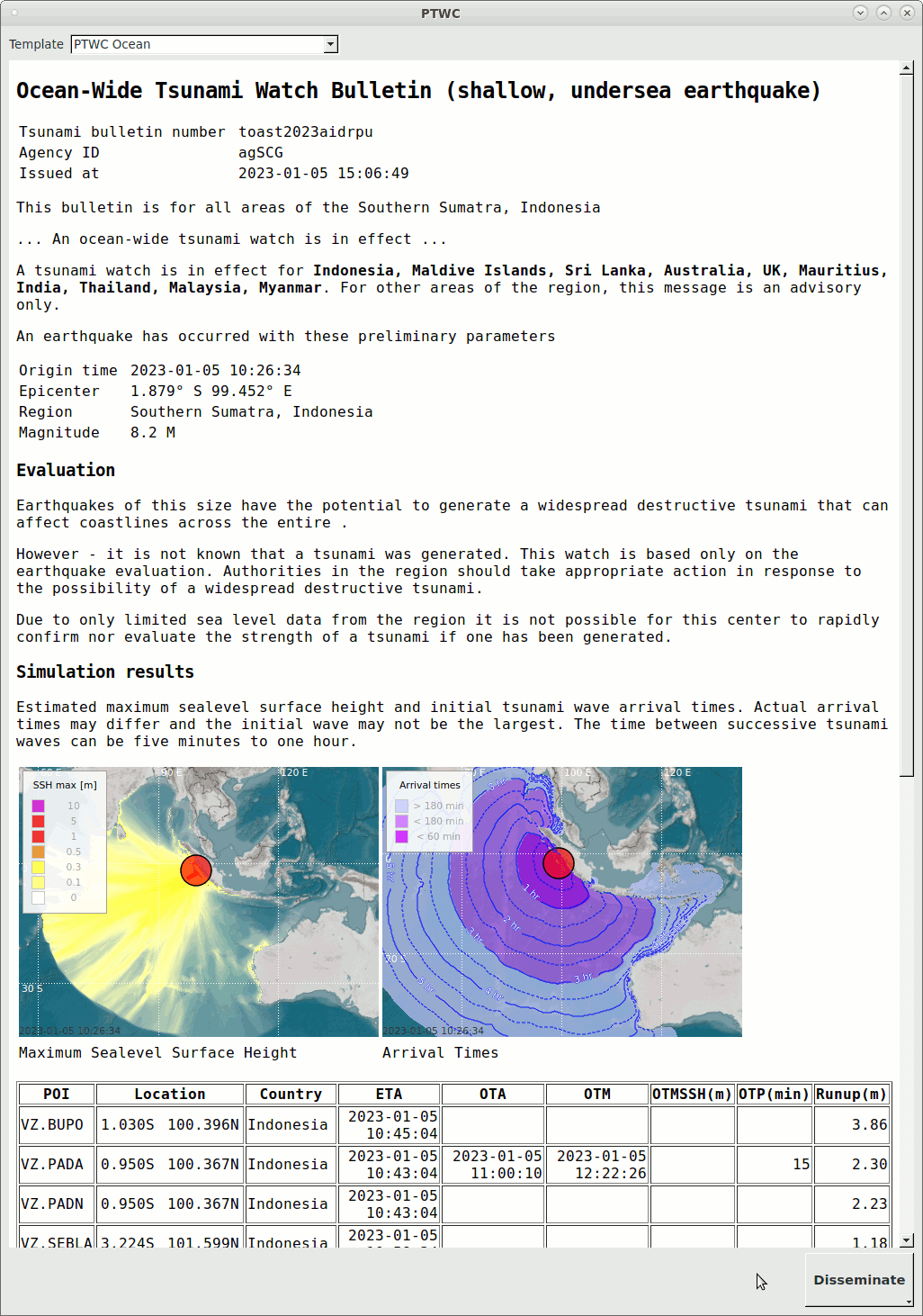
Live Tab PTWC with selected template ptwc_ocean
Multiple templates can be configured for each Live tab. To switch the visible
template, use the selection box at the top.
Upon clicking the Disseminate button, all templates of the current live
tab are exported (more precisely see: Note on export).
To disseminate only a subset of templates, click and hold the button, then
go to With additional options… and select the desired templates.
To suppress the execution of external scripts by the templates using the
function addScript, uncheck Run external scripts.
The button text can be changed with liveTab.$name.buttonText
and the title of the live tab (liveTab.$name.title).
Keep in mind that the export only works if a storage location has been set in
the template.
Note
If Test mode is active, a template can only be activated if the ClearSilver attribute testMode is used somewhere in the template. In this case, the template is executed and the testMode attribute can be used together with if/elif/else ClearSilver flow controls to modify the behavior of the template. For instance, a TEST header could be added or the dissemination while in test mode could be directed to a different target.
The set-up procedure to create a live tab is to:
add a live tab profile (using scconfig + Live tab profile),
add the template profile name(s) to it and
register it at
liveTabs.
Following parameters can be configured in a live tab profile:
Consult hovertips in scconfig for more information on the parameters.
As an example:
liveTab.ptwc.title = PTWC
liveTab.ptwc.templ = ptwc_ocean, ptwc_region
liveTabs = ptwc
Templates configuration
Templates define how the data related to an incident and of the active simulations is visualized and disseminated. They are added and removed in the same way as live tabs:
Add a template profile (using scconfig + Template profile),
configure the parameters and
register the template profile at
templates.types.Configure the logging of external scripts called by templates at
templates.logging.
Following parameters can be configured in a template profile:
template.$name.aoi- (Area Of Interest)
Here is an example configuration for a template profile:
template.ptwc_ocean.aoi = @DATADIR@/toast/world.bna
template.ptwc_ocean.name = "PTWC Ocean"
template.ptwc_ocean.fileName = @DATADIR@/toast/templates/ptwc_ocean.html
templates.types = ptwc_ocean
Hint
Don’t forget to associate templates with live tabs as described in Live Tabs configuration.
Figure Live Tab PTWC with selected template ptwc_ocean illustrates an example of a bulletin generated with a template.
Template file examples
The TOAST template file examples are located at: /home/sysop/seiscomp/share/toast/templates and the example scripts at: /home/sysop/seiscomp/share/toast/scripts. The standard installation package contains the following example templates:
forecast_zones.html, forecast_zones.kml, forecast_zones.txt
gif, video
ptwc_info.html, ptwc_local.html, ptwc_ocean.html, ptwc_region.html
ssh_max.kml
Note
Before using the templates, remove the file ending .example, to avoid overwriting during a TOAST update:
sysop@host:~$ cp $SEISCOMP_ROOT/share/toast/templates/ptwc_ocean.html.example $SEISCOMP_ROOT/share/toast/templates/ptwc_ocean.html
This is the template code ptwc_ocean.html, which generates the bulletin shown in: Live Tab PTWC with selected template ptwc_ocean:
<?cs set:countries = ""
?><?cs each:item = Arrivals
?><?cs if:item.T1Time || item.OTA
?><?cs if:item.Country && ( string.find(countries, item.Country) == -1 )
?><?cs if:countries == ""
?><?cs set:countries = item.Country
?><?cs else
?><?cs set:countries = countries + ", " + item.Country
?><?cs /if
?><?cs /if
?><?cs /if
?><?cs /each
?><?cs set:path = "/tmp/toast/" + strftime(origin.time, "%Y/%m/%d/") + ID
?><?cs var:setCurrentDir(path)
?><?cs var:save("bulletin.html")
?><?cs var:setSize(400,300)
?> <?cs var:addScript("@DATADIR@/toast/scripts/disseminate.sh " + ID)
?><!DOCTYPE HTML PUBLIC "-//W3C//DTD HTML 4.01//EN"
"http://www.w3.org/TR/html4/strict.dtd">
<html>
<head>
<meta content="text/html; charset=utf-8" http-equiv="content-type">
<title>Tsunami Watch Bulletin</title>
</head>
<body>
<h2>
Ocean-Wide Tsunami Watch Bulletin (shallow, undersea earthquake)
</h2>
<p>
</p>
<table>
<tr><td>Tsunami bulletin number </td><td><?cs var:ID ?></td></tr>
<tr><td>Agency ID</td> <td><?cs var:agencyID ?></td></tr>
<tr><td>Issued at</td> <td><?cs var:strftime(creationTime, "%F %T") ?></td></tr>
</table>
<p>
This bulletin is for all areas of the <?cs var:origin.region ?>
</p>
<p>
... An ocean-wide tsunami watch is in effect ...
</p>
<p>
A tsunami watch is in effect for <b><?cs var:countries ?></b>. For other areas of the <?cs var:region ?> region, this message is an advisory only.
</p>
<p>
An earthquake has occurred with these preliminary parameters<br>
</p>
<table>
<tr>
<td>Origin time </td>
<td><?cs var:strftime(origin.time, "%F %T") ?></td>
</tr>
<tr>
<td>Epicenter</td>
<td> <?cs var:strfcoord(origin.latitude, "%.3F° %c") ?> <?cs var:strfcoord(origin.longitude, "%.3F° %C") ?></td>
</tr>
<tr>
<td>Region</td>
<td><?cs var:origin.region ?></td>
</tr>
<tr>
<td>Magnitude</td>
<td><?cs var:float(origin.magnitude, 1) ?> <?cs var:origin.magnitude.type ?></td>
</tr>
</table>
<h3>Evaluation</h3>
<p>
Earthquakes of this size have the potential to generate a widespread destructive tsunami that can affect coastlines across the entire <?cs var:region ?>.
</p>
<p>
However - it is not known that a tsunami was generated. This watch is based only on the earthquake evaluation. Authorities in the region should take appropriate action in response to the possibility of a widespread destructive tsunami.
</p>
<p>
Due to only limited sea level data from the region it is not possible for this center to rapidly confirm nor evaluate the strength of a tsunami if one has been generated.
</p>
<h3>Simulation results</h3>
<p>Estimated maximum sealevel surface height and initial tsunami wave arrival times. Actual arrival times may differ and the initial wave may not be the largest. The time between successive tsunami waves can be five minutes to one hour.
</p>
<table>
<tr><td><img src="<?cs var:addGrid("SSH max", "*", 0, true)
?><?cs var:setOriginSymbol("circle", false)
?><?cs var:setGradientProfile("DefaultProfile")
?><?cs var:renderMeta("ptwc_ocean_sshmax.png", true) ?>" alt = ""></td>
<td><img src="<?cs var:addGrid("Arrival times", "*", 0, true)
?><?cs var:addGrid("Arrival lines", "*", 0, false)
?><?cs var:setOriginSymbol("circle", false)
?><?cs var:setRenderOptions("mapProjection=Rectangular, mapZoomLevel=5.0, showMap=true, showGlobalGeoFeature=false, showGrid=true, showGrayScale=false")
?><?cs var:renderMeta("ptwc_ocean_arrivaltimes.png", true) ?>" alt = ""></td></tr>
<tr><td>Maximum Sealevel Surface Height</td> <td>Arrival Times</td></tr>
</table>
<br />
<table border="1">
<tr>
<th>POI</th>
<th>Location</th>
<th>Country</th>
<th>ETA</th>
<th>OTA</th>
<th>OTM</th>
<th>OTMSSH(m)</th>
<th>OTP(min)</th>
<th>Runup(m)</th>
</tr>
<?cs each:item = Arrivals ?><?cs if:(item.T1Time || item.OTA) && ge(item.Runup, "0.25")
?><tr>
<td><?cs var:item.POI ?></td>
<td><table border="0" width="100%">
<col width="50%">
<col width="50%">
<tr>
<td align="right"><?cs var:strfcoord(item.Location.latitude, "%.3F%c") ?> </td>
<td align="right"><?cs var:strfcoord(item.Location.longitude, "%.3F%c") ?></td>
</tr>
</table>
</td>
<td><?cs var:item.Country ?></td>
<td align="right"><?cs var:item.T1Time ?></td>
<td align="right"><?cs var:item.OTA ?></td>
<td align="right"><?cs var:item.OTM ?></td>
<td align="right"><?cs var:float(item.OTMSSH, 2) ?></td>
<td align="right"><?cs var:float(item.OTP, 0) ?></td>
<td align="right"><?cs var:float(item.Runup, 2) ?></td>
</tr><?cs /if
?><?cs /each ?>
</table>
<p>
This will be the only bulletin issued by the <?cs var:agencyID ?> for this event unless additional information becomes available.
</p>
</body>
</html>
ClearSilver template syntax
Basically, the bulletins are generated based on templates which are filled with data related to an incident, like earthquake origin, simulation results and forecast zone warning levels. To achieve this, TOAST uses a fast and language-neutral HTML template system called ClearSilver. The ClearSilver syntax supports variable substitution, conditionals, loops, functions, local variables etc. Here we explain specific TOAST template variables and functions that can be used in the template definitions. For more information about ClearSilver see the ClearSilver documentation, especially ClearSilver syntax. See also: Template file examples above.
Each ClearSilver command starts with the opening tag <?cs and ends with the closing tag ?>.
Note
A visible template in a LiveTab is executed when a simulation is made active (e.g. by double click) but is also updated by other actions like a change in map position or zoom level or by an event update. However, the ClearSilver functions save and addScript are only executed if the template is disseminated either by or the Disseminate button. Additionally, the isLive() function can be used to explicitly determine whether a template is executed within a LiveTab or by export/dissemination.
Variables
ClearSilver provides many built-in variables, see ClearSilver documentation for more details. TOAST defines additional substitutions (variables and functions) listed below.
The variables can be used in a template in the following way:
<?cs var:origin.time ?>
Common variables
- agencyID
The id of the agency.
- availableTime
Returns the available simulation duration.
- creationTime
The creation time and date of the bulletin.
- ID
The ID of the event.
- testMode
Indicates if the test mode is enabled or disabled.
Origin parameters
- origin.depth
The depth of the earthquake in km.
- origin.latitude
The latitude coordinate of the epicenter in degrees.
- origin.longitude
The longitude coordinate of the epicenter in degrees.
- origin.magnitude
Magnitude of the earthquake.
- origin.magnitude.type
Magnitude type of the earthquake.
- origin.region
The region of the earthquake.
- origin.time
The origin time.
Grid rectangle coordinates
Access the corner coordinates of the last getGrid() export.
- grid.box.top
Latitude coordinate of the grid rectangle’s top edge.
- grid.box.left
Longitude coordinate of the grid rectangle’s left edge.
- grid.box.bottom
Latitude coordinate of the grid rectangle’s bottom edge.
- grid.box.right
Longitude coordinate of the grid rectangle’s right edge.
Map rectangle coordinates
Access the corner coordinates of the TOAST Map perspective.
- map.box.top
Latitude coordinate of the map rectangle’s top edge.
- map.box.left
Longitude coordinate of the map rectangle’s left edge.
- map.box.bottom
Latitude coordinate of the map rectangle’s bottom edge.
- map.box.right
Longitude coordinate of the map rectangle’s right edge.
Datasets
Nearest cities
A record of information of the nearest cities.
- NearestCities.[0..n - 1]
- NearestCities.[i].azimuth
- NearestCities.[i].distance
- NearestCities.[i].name
- NearestCities.[i].lat
- NearestCities.[i].lon
Note
The data set does not contain data until the function
nearestCities() has been called.
Arrivals
- Arrivals.[0..n - 1].[column name]
The i-th value of the arrivals overview. For instance: Arrivals.0.POI.
Forecast Zones
- ForecastZones.[0..n - 1].[column name]
The i-th value of the forecast zones overview. For instance: ForecastZones.0.Name.
Simulations
- simulations.[0..n - 1]
Returns the i-th simulation.
- simulations.[i].id
The simulation ID.
- simulations.[i].type
The simulation backend used for the simulation.
- simulations.[i].source.depth
The depth in km of the simulation earthquake.
- simulations.[i].source.latitude
The latitude coordinate of epicenter in degree of the simulation earthquake.
- simulations.[i].source.longitude
The longitude coordinate of the epicenter in degree of the simulation earthquake.
- simulations.[i].source.magnitude
The magnitude of the simulation earthquake.
- simulations.[i].source.region
The region of the simulation earthquake.
- simulations.[i].source.originTime
The origin time of the simulation earthquake.
Functions
As already mentioned ClearSilver also supports functions. Here an example how to call a function in a template:
<?cs var:setCurrentDir("/tmp/toast") ?>
The TOAST specific functions are listed below.
Common functions
- addTimeSpan(time, seconds)
- Parameters:
time – String with format “%F %T” (yyyy-MM-dd HH:mm:ss).
seconds – The number of seconds as integer value.
- Return type:
String with format as above.
Adds n seconds to the given time.
- currentTime()
- Return type:
String with format “%F %T” (yyyy-MM-dd HH:mm:ss).
Returns the current date and time in UTC.
- fill(in, width, ch, align)
- Parameters:
in – The Input string.
width – The field width of the output.
ch – The fill character which is used when the result is padded to the field width.
align – Alignment of the output.
- Return type:
String
Fills the input string with characters according the alignment(0 = left, 1 = right, 2 = center).
- float(in, int precision)
- Parameters:
in – The input string.
precision – The precision of the output.
- Return type:
String
Formats floating point numbers.
- ge(arg1, arg2)
- Return type:
Boolean
Returns true if arg1 is greater than or equal to arg2.
- gt(arg1, arg2)
- Return type:
Boolean
Returns true if arg1 is greater than arg2.
- le(arg1, arg2)
- Return type:
Boolean
Returns true if arg1 is less than or equal to arg2.
- lt(arg1, arg2)
- Return type:
Boolean
Returns true if arg1 is less than arg2.
- strfazi(azimuth)
- Parameters:
azimuth – Azimuth.
- Return type:
String
Prints the geographic direction.
- strfcoord(in, fmt)
- Parameters:
in – Latitude/ longitude value.
fmt – The format string.
- Return type:
String
Formats coordinates.
- strftime(in, fmt)
- Parameters:
in – The input string.
fmt – The format string. See the strftime man page for available format flags.
- Return type:
String
Formats a given time.
- toLower(in)
- Parameters:
in – The input string.
- Return type:
String:
Converts the given input string to lower case.
- toLocalTime(dateTime)
- Parameters:
dateTime – String with format “%F %T” (yyyy-MM-dd HH:mm:ss) representing UTC date and time.
- Return type:
String in same format.
Converts given time from UTC to local time (system time).
- toUpper(in)
- Parameters:
in – The input string.
- Return type:
String:
Converts the given input string to upper case.
- tz2tz(dateTime, timeZoneIn, timeZoneOut)
- Parameters:
dateTime – String with format “%F %T” (yyyy-MM-dd HH:mm:ss) representing UTC date and time.
timeZoneIn – Input time zone.
timeZoneOut – Output time zone.
- Return type:
String in format as above.
Converts given time from one time zone to an other. Example:
<?cs var:tz2tz("2023-02-14 23:50:00", "Europe/Berlin", "Australia/Sydney") ?>
Functions with relation to bulletins
- isLive()
- Return type:
bool
Returns whether the template is displayed in one of the live tabs.
- useLocalTime(time)
- Parameters:
time – The input time.
- Return type:
bool
Returns whether the time is changed to local time.
- nearestCities(lat, lon, maxDist, minPopulation, maxCount)
- Parameters:
lat – Position for which the nearest cities are to be searched.
lon – Position for which the nearest cities are to be searched.
maxDist – Maximum distance from position to city.
minPopulation – Minimum population of the city.
maxCount – Maximum number of cities.
Fills the dataset Nearest cities
- loadGradient(profile, gradient)
- Parameters:
profile – String: The name of the gradient profile.
gradient – String: The kind of the gradient.
The values are stored in the variable grad and can be iterated over. Useful to generate a legend in HTML. Example:
<?cs var:loadGradient("DefaultProfile", "Forecast zones") ?>
<?cs each:item = grad.DefaultProfile.Forecastzones ?>
    <?cs var:item.color ?> <?cs var:item.text ?>
<?cs /each ?>
- loadJSON(filename)
- Parameters:
filename – String: The filename of the JSON file.
The content is made available as variables and can also be iterated over. This is useful to include data for test runs from external files. Example:
<?cs var:loadJSON("@DATADIR@/toast/templates/training_definitions.json") ?>
<?cs if:testMode ?> Description: <?cs var:description ?>
    <?cs each:zone = testForecastZones ?>
        Name: <?cs var:zone.name ?>
        Code: <?cs var:zone.code ?>
    <?cs /each ?>
<?cs /if ?>
for the JSON file training_definitions.json:
{
    "description": "Test Description",
    "testForecastZones": [
        {
            "name": "Zone 1",
            "code": "1"
        },
        {
            "name": "Zone 2",
            "code": "2"
        }
    ]
}
- loadTranslation(filename)
- Parameters:
filename – String: The filename of the translation map file in INI format.
Loads translation map from file.
Set paths and save bulletins
- save(filename)
- Parameters:
filename – Output file name.
Saves the content of the bulletin to the file with the given filename.
- saveArrivalLines(simType, filename, prettyPrint)
- Parameters:
simType – Simulation type. Example: “EasyWave2”. Use “*” for all types.
filename – Filename of the output GeoJSON file.
prettyPrint – Pretty print JSON output (false/true).
Saves arrival lines of the selected simulation(s) to a file in GeoJSON format. Example:
<?cs var:saveArrivalLines("/tmp/arrivallines.geojson", "*", false) ?>
- resolvePath(path)
- Parameters:
path – Path which can contain SeisComP-variables.
Returns absolute path with resolved SeisComP-variables. Example:
<?cs set:dataToast = resolvePath("@DATADIR@/toast/") ?>
- setCurrentDir(path)
- Parameters:
path –
Changes the current working directory to the directory given in path. If the directory doesn’t exit, it is created.
- tmpFile(template)
- Parameters:
template – Template which may contain the characters ‘XXXXX’.
- Return type:
String:
Generates a unique temporary filename from template, creates and opens the file, and returns the filename. The temporary file is removed when the script is finished.
Add script
Generate images
- render(fileName, showLink)
- Parameters:
fileName – Output file.
showLink – Indicates whether a link to the result is returned or not.
- Return type:
String
Renders the current rendering stack and saves the result as an image to the given filename.
- renderMeta(fileName, showLink)
- Parameters:
fileName – Output file.
showLink – Indicates whether a link to the result is returned or not.
- Return type:
String
The function renderMeta is the same as render, except that it additionally writes meta information about the rendering stack into an extra file with ending .meta in JSON format. This is useful if images have to be georeferenced.
- getGrid(type, simType, step, fileName)
- Parameters:
type – Type of the grid. Currently available: “SSH max”, “SSH”, “Arrival times”.
simType – Simulation type. Example: “EasyWave2”. Use “*” for all types.
step – Time step.
fileName – Output file.
Save the simulation results for the layer name of simulation type simType for the given time step as an image to the given filename. Sets
grid.box.left,grid.box.right,grid.box.topandgrid.box.bottomto the grid coordinates.
Note
See function saveArrivalLines to export arrival lines in GeoJSON format.
Configure images
- addGrid(type, simType, step, config)
- Parameters:
type – Type of the grid. Currently available: “SSH max”, “SSH”, “Arrival times”, “Arrival lines”.
simType – Simulation type. Example: “EasyWave2”. Use “*” for all types.
step – Time step in seconds.
config – Configuration of the grid. A comma separated list with ‘=’ to assign the value to the variable (e.g. “legendTitle=Arrival times, arrivalFontSize=10, legendOrientation=’vertical’”) For available variables see the description below.
Adds a grid to the rendering stack.
Supported variables for the config parameter:
Variable
Type
showLegend
bool
legendTitle
string
legendTextAlign
‘left’, ‘right’, ‘center’
legendFontSize
int
legendSpacing
int
legendOrientation
‘horizontal’, ‘vertical’
- addLayer(type, config)
- Parameters:
type – Name of the layer.
config – Configuration.
Adds a layer to the rendering stack. Currently available: “forecast zones”.
Layer
Config options
forecast zones
See supported config parameters for addGrid, additionally: gradient (string), gradientProfile (string), drawFilled (bool), drawInactive (bool), drawInactiveColorized (bool), inactiveFillColor (string), inactiveLineColor (string), defaultLineColor (string), brush (string)
- setOriginSymbol(shape, fill)
- Parameters:
shape – Name of the shape. Available shapes are circle (black border as in map view), circle-seiscomp (red border as in SeisComP) and star. The default shape is circle.
fill – Indicates whether the symbol should be filled or not (default: filled).
Sets the origin symbol of the map.
- setGradientProfile(name)
- Parameters:
name – Gradient profile name.
Set the gradient profile to the given name.
For more information on color gradients, see: Color profiles, gradients and colors configuration.
- setRenderOptions(config)
- Parameters:
config – Configuration. A comma separated list with ‘=’ to assign the value to the variable (e.g. “mapProjection=Rectangular, mapZoomLevel=8.0”)
Sets rendering options. Supported options are given below.
Option
Type
Example
mapCenter
float float
-5.0 100.0
mapProjection
string
Rectangular
mapZoomLevel
float
8.0
showMap
bool
true
showGlobalFeature
bool
false
showGrid
bool
true
backgroundColor
string
white
showGrayScale
bool
false
encodeBase64
bool
false
- setScenarioColors(colors)
- Parameters:
colors (string (list separated by ',', e.g. "white, red").) – List of colors.
Set the colors of the active simulations, for example used for arrival lines color. The order defines the assignment to the simulations based on the selection in TOAST.
- alignLegends(inout, orientation, align)
- Parameters:
inout – Legends inside or outside of the image (“in”,”out” or “” (default: inside)).
orientation – Horizontal or vertical legend (“horizontal”, “vertical” or “” (default: vertical)).
align – Alignment of legend (“left”, “right”, “bottom”, “top” or mixed values, default: top).
Set the alignment and the orientation of the legends and if the legends should be rendered in or outside the image.
- setGlobalLayerConfig(str)
- Parameters:
str – String with information about how to show the legend text.
- Return type:
string
See layer configuration for more detail.
- setWatermark(str)
- Parameters:
str – String with information about the copyright.
- Return type:
string
Set information about the file e.g. the date of copyright.
- showCurrentStepTime(step)
- Parameters:
step – Time step in seconds.
Sets the current time step.
- forecastZone(id)
- Parameters:
id – ID of a forecast zone.
- Return type:
string
Returns the forecast zone in kml format.
Set image size
- setDisplayRect(lat, lon, height, width)
- Parameters:
lat – Latitude value.
lon – Longitude value.
height – Height of the rectangle.
widht – Width of the rectangle.
Sets the visible region of the map from bottom-left corner, width and height. The aspect ratio needs to be similar to the selected output size to fit.
- setSize(width, height)
- Parameters:
width – The width of the output image.
height – The height of the output image.
Sets the size of the output image.
- setMegapixel(megaPixel)
- Parameters:
megaPixel – Number of mega pixel (floating point).
Sets the image size to approximately megaPixel.