
scmv
Map view
Description
scmv visualizes the actual information regarding earthquakes, trigger status, ground motion and station quality. This information is visualized in a map showing also the topography of the region including bathymetry, state borders and geologic faults. scmv provides two different tabs with maps showing the ground motion and the network status.
Ground motion status
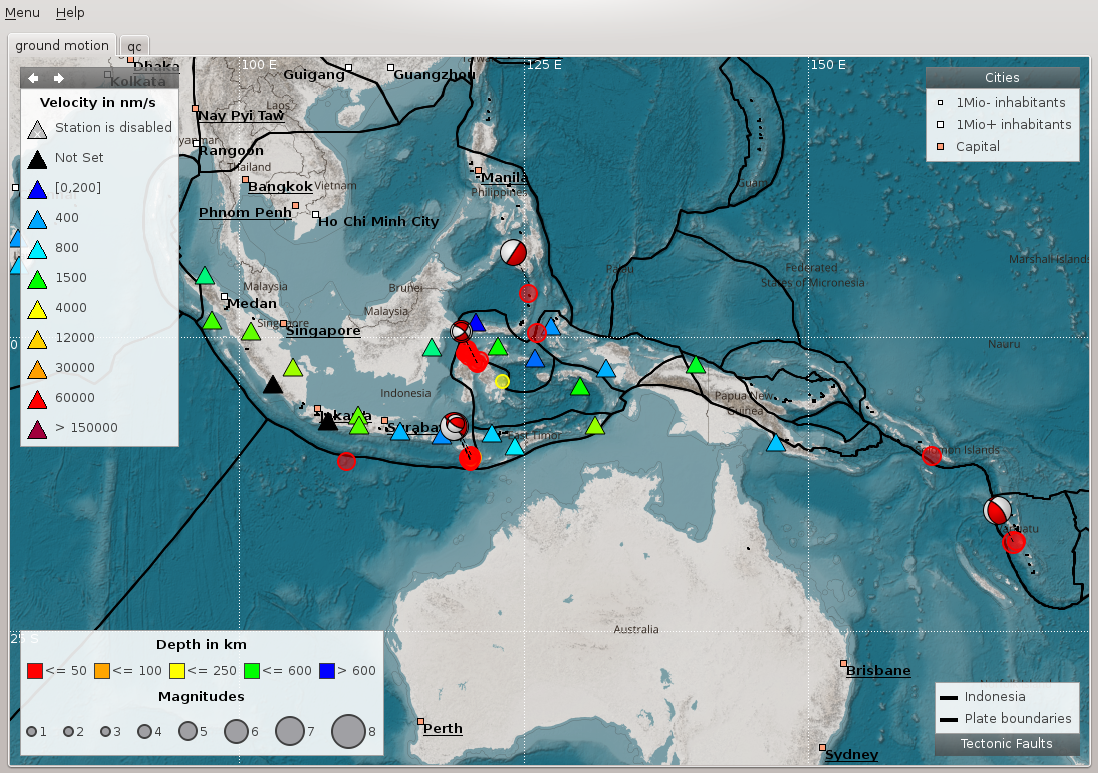
The ground motion tab (fig. Ground motion tab) shows the actual groundmotion in nm/s at each station color-coded. Furthermore the trigger status (new picks) of the stations are announced by blinking triangles (the same in all other tabs). In case a new pick is associated to an event, the blinking color changes from red to green (default). Events are represented by open circles and the depth is color-coded. By right mouse click on the symbol of a station more detailed information are shown in an information widget (fig. Station information widget).
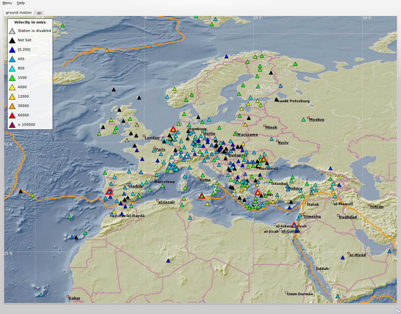
Ground motion tab
Tab 1-2 = Ground Motion, Network Status tab; Station A = station with ground motion between 0 and 200 nm/s; Station B = triggering (red blinking) station; Station C = station of undefined status; Station D = triggering and associated station (green blinking); EQ = location of the earthquake/event; P = spreading of the P-wave; S = spreading of the S-wave; Legend = ground motion scale.
Network status
The network status tab (fig. Network status tab) visualizes the quality control parameters of all shown stations. The colors of the triangles represent the data the selected parameters of a station, e.g. latency or delay. More detailed information about station quality can be derived by opening an information widget (fig. Station information widget left) with a right mouse click on the symbol.
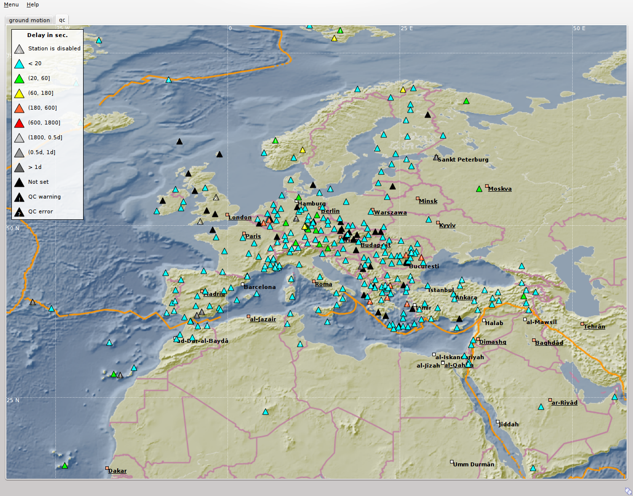
Network status tab
Station A = station with up to 20 sec data latency/delay; Station B = station with up to 10 min data latency/delay and a warning; Station C = disabled station; EQ = location of a recent or historic earthquake/event; Legend = scale of the delay; Status = connection status.
The visualized QC parameters can be selected in the QC parameters widget of scmv.
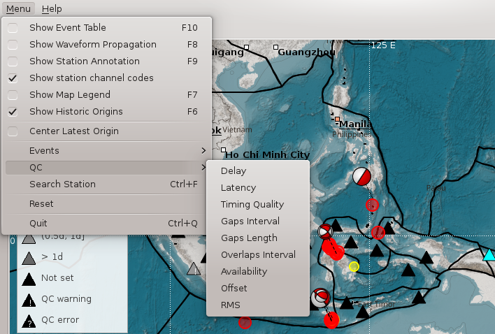
QC parameters selection widget
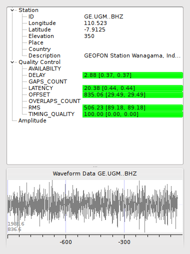
The station information widget opens by right mouse click on a station symbol in one of the scmv maps. The widget gives a more detailed list of parameters. For a station general information (coordinates, network code etc.), quality parameter (latency, gaps etc.), amplitude information and the actual waveform data are provided. For an event information like the location, the number of stations and the azimuthal gap are shown.
Station information widget
The info widget of a station shows station information like network code and location. The quality of the station can be checked here. The lower part shows the last 15 minutes of waveforms including picks (if available).
Event information
In addition to the current event scmv also shows all events it has currently saved in its session as circles. This depends on the configured time span it remembers events. Showing the events can give a convenient overview of the network activity. If available focal mechanisms are displayed with dashed lines connecting to their location. The circles and focal mechanisms are again colored by their depth and sized by magnitude.
The events shown an the map can be confined by selecting the mode and the status of preferred origins in the event selection widget.
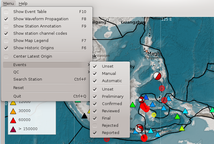
Event selection widget
The event information widget opens by right mouse click on an event symbol. It shows event details. Clicking on the “Show Details” button allows to open the preferred origin of the event in other GUIs such as in scolv.
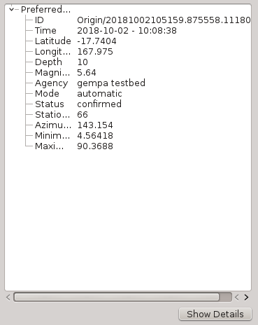
Event information widget
Hotkeys
Hotkey |
Description |
|---|---|
F2 |
Setup connection dialog |
F3 |
Toggle ray paths and associated stations |
F6 |
Hide propagation of P and S waves |
F7 |
Toggle legend |
F8 |
Toggle historic origins |
F9 |
Toggle station annotation |
F10 |
Toggle event list (event tab) |
F11 |
Toggle full screen mode |
CTRL + f |
Seach station |
Arrows |
Move focus |
Mouse wheel |
Zoom in or out |
Double click |
Center map |
Right mouse button |
Open info widget |
Mid mouse button |
Set preliminary origin |
Use cases
Get station information
Position the mouse above a triangle representing a station.
Click the right mouse button for opening the station info widget.
Choose one station in case several stations are in the selection range.
Get event information
Position the mouse above a circle representing a location of an event.
Click the right mouse button for opening the event info widget.
Choose one event in case several events are in the selection range.
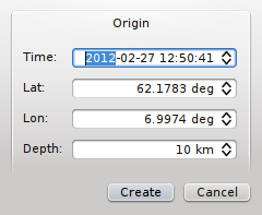
Set preliminary origin
Position the mouse in the map
Press the middle mouse button
Set date & time and latitude, longitude & depth
Press “Create” to open the origin in another GUI, e.g. scolv.
Search station/network
Press CTRL + f
Type station/network name
Double click in a station in the list to center the map at this location
Configuration
etc/defaults/global.cfgetc/defaults/scmv.cfgetc/global.cfgetc/scmv.cfg~/.seiscomp/global.cfg~/.seiscomp/scmv.cfgscmv inherits global options.
-
displaymode¶ Type: string
Set one of the available displaymodes: groundmotion or qualitycontrol
-
groundMotionRecordLifeSpan¶ Type: int
Unit: s
Sets the maximum latency in seconds of the ground motion records to be valid. Default is
300.
-
removeEventDataOlderThan¶ Type: double
Unit: s
Sets the time span in seconds to keep events. Default is
43200.
-
readEventsNotOlderThan¶ Type: double
Unit: s
Sets the time span in seconds to read events initially from database. Default is
0.
-
centerOrigins¶ Type: boolean
If a new origin/event is set/selected this option defines if the map is centered or not at the origin location. Default is
false.
-
eventActivityLifeSpan¶ Type: double
Unit: s
Time span of which an event is active after origin time to show blinking associated stations. Default is
900.
-
expiredEventsInterval¶ Type: double
Unit: s
A positive value (greater than zero) defines the interval to check for expired events. A negative or zero value disables the interval check and expired events are only removed when a new event is declared or an existing event is updated. Default is
0.
-
annotations¶ Type: boolean
Enables/disabled drawing of station annotations at startup. Default is
false.
-
annotationsWithChannels¶ Type: boolean
Enables/disabled drawing of station annotations with location/channel codes. Default is
true.
-
mapLegendPosition¶ Type: string
Sets the location of the map symbol legend (QC, ground motion). Use either: topleft, topright, bottomright or bottomleft. Default is
topleft.
-
eventLegendPosition¶ Type: string
Sets the location of the event symbol legend. Use either: topleft, topright, bottomright or bottomleft. Default is
bottomleft.
-
eventTable.visible¶ Type: boolean
Whether to show the event table initially or not. Default is
false.
-
eventTable.columns¶ Type: list:string
The columns that are visible in the table. If nothing is specified then all columns are visible. Valid column names are: “Event”, “Origin Time”, “Magnitude”, “Magnitude Type”, “Region”, “Latitude”, “Longitude”, “Depth”.
-
stations.groundMotionFilter¶ Type: string
Sets the filter applied to determine ground motion.
Note
display.* Allows to define an initial rectangular region for the map.
-
display.latmin¶ Type: double
Unit: deg
Minimum latitude in degrees. Default is
-90.
-
display.lonmin¶ Type: double
Unit: deg
Minimum longitude in degrees. Default is
-180.
-
display.latmax¶ Type: double
Unit: deg
Maximum latitude in degrees. Default is
90.
-
display.lonmax¶ Type: double
Unit: deg
Maximum longitude in degrees. Default is
180.
Command-line
scmv [options]
Generic
-
-h,--help¶ show help message.
-
-V,--version¶ show version information
-
--config-filearg¶ Use alternative configuration file. When this option is used the loading of all stages is disabled. Only the given configuration file is parsed and used. To use another name for the configuration create a symbolic link of the application or copy it, eg scautopick -> scautopick2.
-
--pluginsarg¶ Load given plugins.
-
--auto-shutdownarg¶ Enable/disable self-shutdown because a master module shutdown. This only works when messaging is enabled and the master module sends a shutdown message (enabled with –start-stop-msg for the master module).
-
--shutdown-master-modulearg¶ Sets the name of the master-module used for auto-shutdown. This is the application name of the module actually started. If symlinks are used then it is the name of the symlinked application.
-
--shutdown-master-usernamearg¶ Sets the name of the master-username of the messaging used for auto-shutdown. If “shutdown-master-module” is given as well this parameter is ignored.
Verbosity
-
--verbosityarg¶ Verbosity level [0..4]. 0:quiet, 1:error, 2:warning, 3:info, 4:debug
-
-v,--v¶ Increase verbosity level (may be repeated, eg. -vv)
-
-q,--quiet¶ Quiet mode: no logging output
-
--componentarg¶ Limits the logging to a certain component. This option can be given more than once.
-
-s,--syslog¶ Use syslog logging back end. The output usually goes to /var/lib/messages.
-
-l,--lockfilearg¶ Path to lock file.
-
--consolearg¶ Send log output to stdout.
-
--debug¶ Debug mode: –verbosity=4 –console=1
-
--log-filearg¶ Use alternative log file.
Messaging
-
-u,--userarg¶ Overrides configuration parameter
connection.username.
-
-H,--hostarg¶ Overrides configuration parameter
connection.server.
-
-t,--timeoutarg¶ Overrides configuration parameter
connection.timeout.
-
-g,--primary-grouparg¶ Overrides configuration parameter
connection.primaryGroup.
-
-S,--subscribe-grouparg¶ A group to subscribe to. This option can be given more than once.
-
--content-typearg¶ Overrides configuration parameter
connection.contentType.
-
--start-stop-msgarg¶ Sets sending of a start- and a stop message.
Database
-
--db-driver-list¶ List all supported database drivers.
-
-d,--databasearg¶ The database connection string, format: service://user:pwd@host/database. “service” is the name of the database driver which can be queried with “–db-driver-list”.
-
--config-modulearg¶ The configmodule to use.
-
--inventory-dbarg¶ Load the inventory from the given database or file, format: [service://]location
Records
-
--record-driver-list¶ List all supported record stream drivers
-
-I,--record-urlarg¶ The recordstream source URL, format: [service://]location[#type]. “service” is the name of the recordstream driver which can be queried with “–record-driver-list”. If “service” is not given “file://” is used.
-
--record-filearg¶ Specify a file as record source.
-
--record-typearg¶ Specify a type for the records being read.
Cities
-
--city-xmlarg¶ The path to the cities XML file. This overrides the default paths. Compare with the global parameter “citiesXML”

