Introduction
The GDS is a modular expandable dissemination and publication server. The purposes of GDS are:
Automatic and manual dissemination of information about earthquake, tsunamis and others
Provision of information as bulletins, figures showing maps, waveforms or diagrams, or externally provided files such as reports in PDF format
Filtering of the supplied information based on earthquake parameters such as location or magnitude and the subscribed recipients
Dissemination using many services which can be customized
Flexible format customization of the disseminated information including multi-language support
Fast manual dissemination by efficient template selection based on configurable pull-down selection menus and interactive parameter input.
GDS uses a plugin technology to import earthquake solutions from different sources, filter the incoming earthquake information and disseminate template based messages through various communication channels such as SMS, email, fax and web. GDS complements the functionality of SeisComP in the domain of dissemination of notifications and warnings.
Figure 35 shows GDS architecture. It is composed of a bunch of individual modules which acquire (gray), process (green) and disseminate (blue) earthquake information. In addition a web interface (red) exists which allows to configure, interact and review the dissemination process.
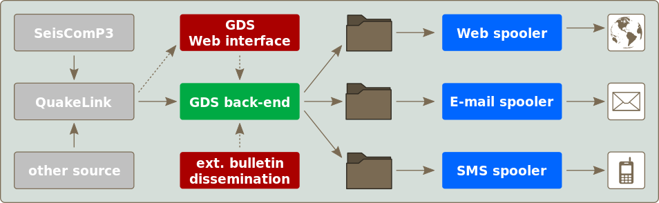
Figure 35: Architecture of GDS
Acquisition
gempa GmbH developed a new protocol to exchange earthquake information in real-time or time window based with QuakeLink, an appendant software module. The QuakeLink server is the central acquisition component. It offers import plugins to get earthquake information from different sources such as a SeisComP system. The GDS back-end and the web interface connects to the QuakeLink server listening for new earthquake information or to query historic events.
Processing
The GDS back-end connects to QuakeLink to receive earthquake updates. Based on configured criteria new earthquake information is filtered for matching subscriptions. Subsequently subscription specific bulletins are created with the help of configurable templates. These bulletins are stored in spool directories accompanied by an address list.
For the configuration of the processing step a web interface is provided which operates on a database provided by the GDS back-end. In addition the web interface directly connects to the back-end to allow the user to manually control the dissemination process. This includes (re-)triggering the dissemination of events as well as reviewing and editing of bulletins prior to dissemination. The list of available earthquakes for dissemination is fetched from the QuakeLink server.
Dissemination
Almost any service, e.g., email, SMS, fax, Twitter, TV, web, and many more, can be used to disseminate the information. For each service a separate spool directory is used. Spooler applications monitor these directories and send the data to the various recipients. The advantages of decoupling the GDS back-end from the actually dissemination work are:
Reliability - If one dissemination channel resp. Spooler is blocked it will not interfere with other channel.
Flexibility - A Spooler may be stopped, reconfigured or even exchanged without any affect on the GDS back-end. Also custom Spooler may be coded in any possible programming language since the data is exchanged via plain files.
Reusability - Often dissemination tools working with files already exist and may be used right away without or with very little modification.
For convenience reasons Spooler applications may be added to the GDS back-end configuration which will cause them to be started as sub processes.
New version in 2019
A totally new version of GDS is provided as of mid 2019. The new features include:
A totally updated web interface for controlling the dissemination and log review
Enhanced support for manual dissemination based on pre-configured content templates
New filter and spooler options, e.g.
add distance and direction to the nearest and other city to bulletins
add examples for generating shake maps using SIGMA
Event selection by Flinn-Engdahl region
Read the CHANGELOG of GDS for a complete list.