gaps
gempa application server for the web.
Description
GAPS provides a collection of web-based client tools running in a web browser anywhere on PCs, tablets or smartphones to interface with a SeisComP installation that operates the gaps server. Through GAPS, operators gain insight into a remote SeisComP data acquisition and processing system and can interact with it. In full-screen mode, the modules are excellent for demonstrating the performance of the SeisComP server system in a show room.
Here we refer to GAPS as the gempa product and to gaps as the provided module which can be configured and started within SeisComP.
Overview
When connecting to a gaps server, the start page is shown. From there the individual web modules can be reached. These are:
EQView: View event catalogs and detailed parameters in custom widgets on a map,
StationView: View stations and their parameters along with events on a map,
TraceView: View raw or filtered waveforms from stations along with phase picks and event parameters. Select the station interactively on a map,
OriginLocatorView: Browse and view event catalogs, select and analyze events by viewing or selecting phase detections and processing waveforms.
Read the full instructions on using these web modules in section Application: Client Modules.
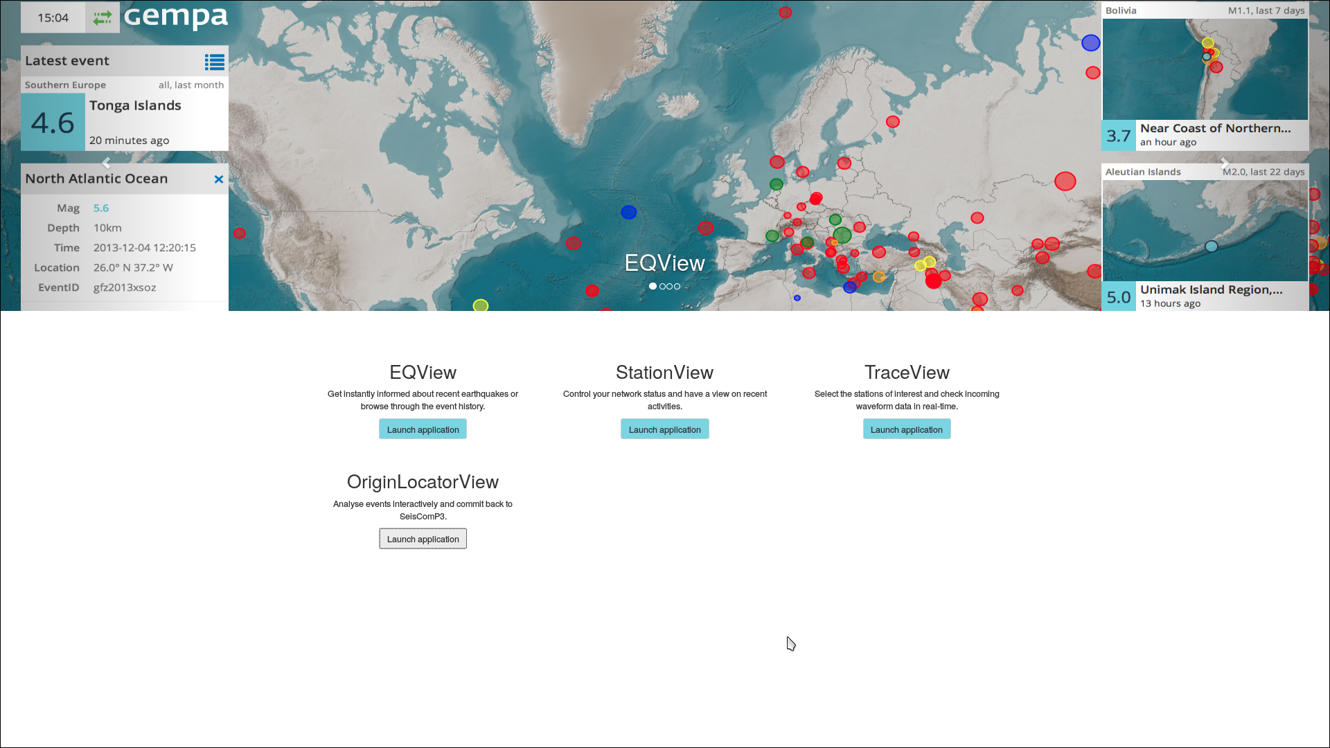
Figure 1: GAPS start page (full-screen mode, example from gempa’s demo website).
gaps reads event parameters from QuakeLink [3] which is provided along with GAPS. It uses maps stored as tiles Tiles [4]. The web applications can be customized to show different details on maps and catalogs. All may be secured on multiple levels. In this way authorized users can process data and commit the results to the SeisComP server system as if they were directly connected to a SeisComP system. Read the section Installation and Setup to learn about your options.
System requirements
QuakeLink [3] serves event parameters to gaps. In order to have gaps functioning, a QuakeLink server must therefore be accessible remotely or configured locally along with SeisComP and started.
gaps reads maps from tiles provided by the plugin mbtiles [7] provided by gempa’s mappprojection package which must be installed.
In a basic setup, the gaps and QuakeLink HTTP interfaces are directly accessed by the web browser. Make sure that the interfaces are configured and accessible by the client.
The steps for installation and configuration are explained in section Installation and Setup. All configuration parameters are detailed in section Module Configuration.
Installation and Setup
This chapter describes in detail how to setup gaps for common use cases with:
QuakeLink configuration,
gaps server and customization,
For a quick installation and setup on a local machine follow the instruction in sections:
Later you may improve further by following the full procedure set out below. E.g. you may set access control rules (read Connection and access control) and integrate gaps into your web server (read Web server integration (NGINX)) for visibility from your or any public network. You may even generate custom web pages as set out in Custom pages.
Package installation
GAPS consists of 2 packages that should be installed for full functionality:
gaps-server for the gaps server application,
gaps-frontends/gaps-frontends-all for the gaps web apps (client applications) without/with OriginLocatorView.
Install the GAPS and the mapprojections packages in addition to SeisComP via gsm package manager. You may install GAPS with or without the OriginLocatorView.
Installation without OriginLocatorView:
./gsm install mapprojections gaps-server gaps-frontends
or
Installation with OriginLocatorView:
./gsm install mapprojections gaps-server gaps-frontends-all
The quakelink package must be installed as well unless you want to connect to an external QuakeLink server:
./gsm install quakelink
QuakeLink
Hint
This chapter on QuakeLink may be skipped if QuakeLink is already running or if another external QuakeLink server shall be used for gaps as described in Connect GAPS with QuakeLink.
Configure and start QuakeLink and populate it with event parameters.
Configure QuakeLink in
$SEISCOMP_ROOT/etc/quakelink.cfg or use scconfig [11].
Enable QuakeLink HTTP web interface:
# Port to listen for HTTP request
QL.http.port = 18080
Enable and start the services
seiscomp enable quakelink
seiscomp start quakelink
For importing event parameters into QuakeLink, either
For testing and an overview over available events open the default QuakeLink URL in a web browser:
http://localhost:18080
gaps server
gaps requires to configure:
Module parameters for general properties,
Bindings for defining stations visible in the web frontends
in addition to the connection to QuakeLink and the maps.
In order to bind a station to gaps, e.g. showing its symbol in the station view, create a gaps binding for that station with parameter enable set to true. Stations that have not been bound to gaps will be removed from the inventory and therefore not be shown.
Configure gaps in $SEISCOMP_ROOT/etc/gaps.cfg or use
scconfig [11]. A subset of control parameters is described in this section
but a complete list can be found in Configuration.
More detailed help for all parameters can be found in the configuration of the
gaps module in scconfig (mouse-over the respective parameter).
Connect GAPS with QuakeLink
Configure the connection of gaps to QuakeLink.
Set the URI for requesting events from QuakeLink in
quakelink. This URI is used as a default for all web applications. e.g.:quakelink = http://your_server:18080/events/query
Set the QuakeLink proxy connection initiated by gaps in
quakelinkProxy: to convert and forward single events from QuakeLink to the browser, e.g.:quakelinkProxy = ql://your_server:18010
Hint
The parameters
quakelinkandquakelinkProxyneed to point to the same server address and must be available to the client. Hence, for the server address you may uselocalhost if you are running the gaps frontends on the same machine as the gaps server and Quakelink or if the connection to QuakeLink and gaps is controlled via NGINX or another web server.
a public IP address or name if gaps and QuakeLink run on a publicly available computer.
Compare also with the settings in sc2ql [10].
Enable and start the services
seiscomp enable gaps
seiscomp start gaps
or restart gaps after applying further configurations later on
seiscomp restart gaps
For testing the initial setup of gaps try to open the default gaps URL in a web browser, e.g firefox where the GAPS start page should appear:
firefox http://localhost:8080Note
If the gaps front end displays the notification
Could not reach server, try again in 10 sand the browser console (Ctrl+Shift+I) contains CORS error message likeCross-Origin Request Blocked: The Same Origin Policy disallows reading the remote resource at http://localhost:18080/events/query?archived. (Reason: CORS request did not succeed), it is very likely that the QuakeLink server is not up and running. Please check the QuakeLink log file under$HOME/.seiscomp/log/quakelink.log
Map properties
The location of maps stored as Tiles [4] as well as the zoom levels can be configured. Maps from OpenStreetMap [2] or generated by the user can be included. High resolution maps can also be purchased from gempa GmbH [6]. Contact gempa GmbH for the details.
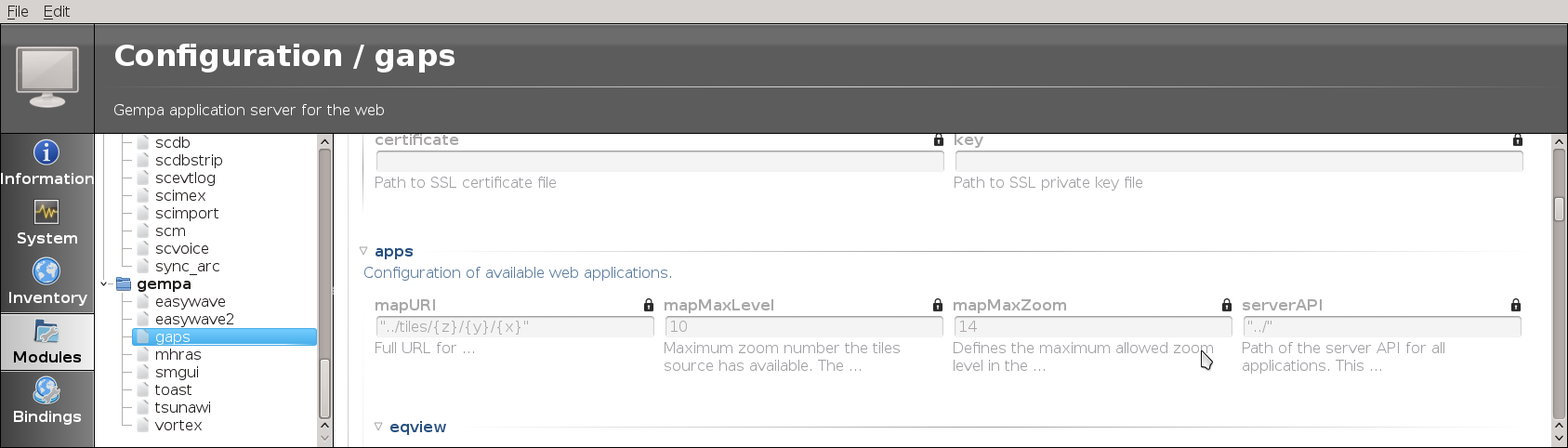
Figure 2: scconfig: window for setting the map parameters.
Add the mbtiles plugin to global parameters and configure
map.locationandmap.typewith the map tile file or URL and the map type, respectively.plugins = ${plugins}, mbtiles map.location = [file/map URL] map.type = [type]
Note
These parameters are typically set by global module configuration in
$SEISCOMP_ROOT/etc/global.cfgbut they may be overridden in gaps in$SEISCOMP_ROOT/etc/gaps.cfg.The maps are available through global parameters but you may adjust map features
Set
tileDBto the MBTiles tile database if gaps should serve tiles itself. Leave it empty if mapURI is configured with a remote tile server inapps.mapURI.tileDB = /home/data/maps/world-11/world-11.mbtiles
For using a remote tile server set
apps.mapURI. Provide start values for zoom level {z}, latitude {y} and longitude {x}, e.g.:locally stored maps:
apps.mapURI = "../tiles/{z}/{y}/{x}"
a remote server
apps.mapURI = "http://example.com:8080/tiles/{z}/{x}/{y}"
or a OpenStreetMap server
apps.mapURI = "http://tile.openstreetmap.org/{z}/{x}/{y}.png"
Note
OpenStreetMap and probably other tile server expect the tile indexes as z, x, y whereas the built-in gaps tile server expects z, y, x.
Set
apps.mapMaxLevelto the maximum zoom number for which the tiles source has available. The tiles on all zoom levels higher thanapps.mapMaxLevelwill be loaded atapps.mapMaxLevellevel and auto-scaled.Adjust
apps.mapMaxZoomto fix the maximum allowed zoom level in interactive maps. The maximum level must be provided by the maps server.Define the region of the initially shown maps in StationView and TraceView by
apps.mapRegion.*parameters:# The minimum latitude of the region. apps.mapRegion.minimumLatitude = -90 # The minimum longitude of the region. apps.mapRegion.minimumLongitude = -225 # The maximum latitude of the region. apps.mapRegion.maximumLatitude = 90 # The maximum longitude of the region. apps.mapRegion.maximumLongitude = 225
Set the parameter
apps.logoPathto show customized logo images for your institution in the EQView or the StationView. By default, “GEMPA” will be shown.
Connection and access control
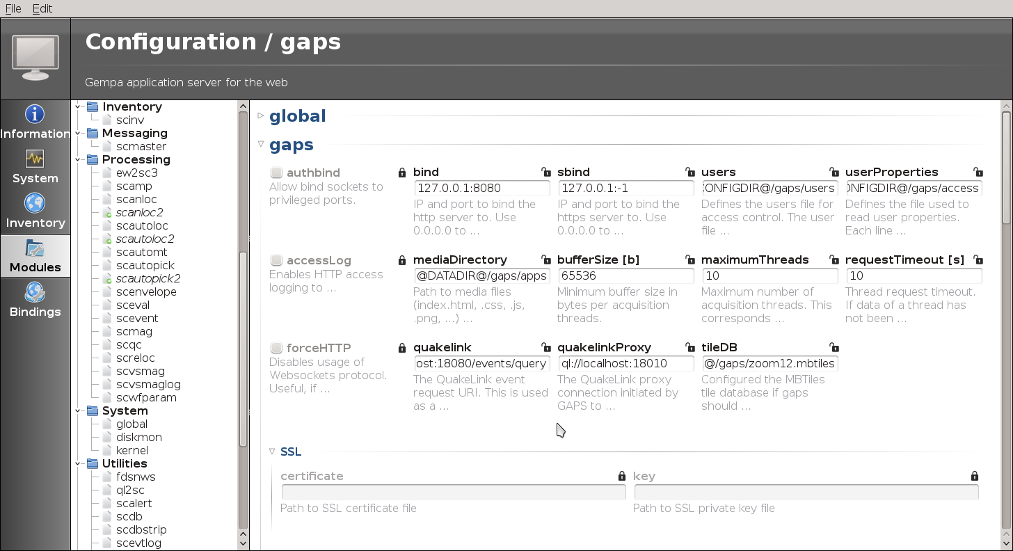
Figure 3: scconfig: window for setting the access control parameters.
Connection control: Control the client access by providing IP and port to bind the http server to by
bind. Use 0.0.0.0 to bind to all interfaces. Either the port or the IP address may be omitted, e.g. “0.0.0.0” or “:1234”. Leave empty to run without providing a http server.Access only from the localhost of the server using port 8080 (default):
bind = 127.0.0.1:8080
Access only from all remote IP addresses using port 8080:
bind = 0.0.0.0:8080
For connecting via https configure
sbind. Port “:-1” (default) rejects the usage of https.Access control: Re-locating events and committing the results in the OriginLocatorView is protected by username and password. Different roles can be assigned to the users.
Configure
usersfor defining users names with encrypted passwords which may operate the OriginLocatorView. Define the file containing user names and encrypted passwords:users = @CONFIGDIR@/gaps/users
The users file contains the user details (name:encrpyted-password). Add one line per user e.g. for user sysop:
sysop:encrpyted-password
Create the content of this file with user name and the encrypted password. For encrypting the password it is recommended to apply a strong algorithm such as sha-256 or sha-512. The password encryption tool may depend on the Linux flavour.
When mkpasswd is available the command
user=sysop pw=`mkpasswd -m sha-512` && echo $user:$pw;
generates a line for e.g. user “sysop”.
Alternatively use, e.g. on RHEL or CentOS:
python -c 'import crypt,getpass; print(getpass.getpass("Name: ")+":"+crypt.crypt(getpass.getpass(),crypt.mksalt(crypt.METHOD_SHA512)))'
Different user properties can be assigned to users or the OriginLocatorView. Currently, the two properties are interpreted:
staff: full access to relocating events and committing the results to the SeisComP system.
guest: limited access. Only relocating events is allowed but committing the results is prohibited.
The properties are provided in a file defined by
userProperties, e.g.:userProperties = @CONFIGDIR@/gaps/access
Each line contains the user name and a list of properties in format “username:prop1,prop2,prop3”. Those properties are used to grant access to specific functionalities in gaps such as sending processing results back.
Example of the file
@CONFIGDIR@/gaps/accessfor users sysop, user1 and user2 (one line per user):sysop:staff user1:staff user2:guest
EQView
Widgets in the EQView can be configured allowing specific focusing on source regions and earthquakes therein with that exceed a given magnitude threshold.
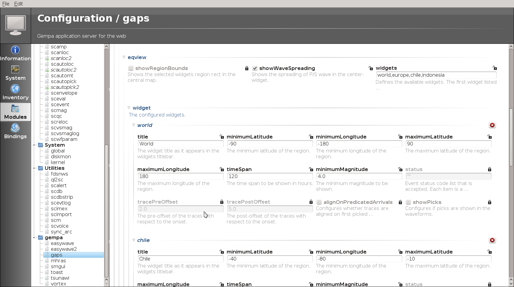
Figure 4: scconfig: window for setting the EQView widget control parameters.
Set the parameter apps.logoPath to show customized logo images.
eqview.widgets
Controls which of the defined widgets profiles are shown, e.g.:
apps.eqview.widgets = world, europe, chile, indonesia
Widgets
Properties of all widgets profiles defined in eqview.widgets.
Add one profile block per profile.
Example for widget profile europe, where all event with magnitudes greater than 2 are shown for Europe.
# The widget title as it appears in the widgets titlebar.
apps.eqview.widget.europe.title = Europe

# The minimum latitude of the region.
apps.eqview.widget.europe.minimumLatitude = 20

# The minimum longitude of the region.
apps.eqview.widget.europe.minimumLongitude = -20

# The maximum latitude of the region.
apps.eqview.widget.europe.maximumLatitude = 60

# The maximum longitude of the region.
apps.eqview.widget.europe.maximumLongitude = 40.0

# The time span to be shown in hours.
apps.eqview.widget.europe.timeSpan = 120

# The minimum magnitude to be shown.
apps.eqview.widget.europe.minimumMagnitude = 2.0
StationView
Provide the gaps.mapRegion.* parameters to customize the region shown
initially on the map.
Set the parameter apps.logoPath to show customized logo images.
TraceView
Filters used in TraceView can be configured by apps.traceview.filters.
Read the section Filter Grammar [1] for details on the
possible filters and filter grammar in SeisComP.
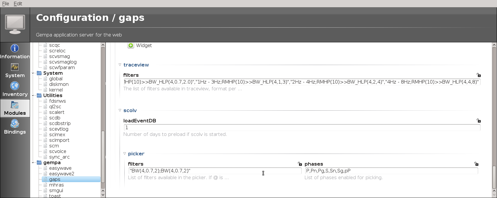
Figure 5: scconfig: window for setting the control parameters for OriginLocatorView and TraceView.
Configure the list of filters that are available in TraceView in the form
"description;filter_chain","...",...
apps.traceview.filters = "0.7Hz - 2Hz;RMHP(10)>>ITAPER(30)>>BW(4,0.7,2.0)","@4Hz - 8Hz;RMHP(5)>>ITAPER(10)>>BW(4,4,8)"
where the leading “@” defines the default filter.
OriginLocatorView
Configurable among others:
apps.scolv.loadEventDB: The number of days before present for which events are initially shown in the event list.apps.traceview.filters: Filters available before picking.Seismic phases for which the theoretical arrival times are shown on the traces.
apps.scolv.useUTC: Use UTC for time zone instead of that of the local system.Time window parameters: Control the amount of data to load and process in the picker.
See the figure and filters in Trace View for details.
Custom pages
Installing the gaps server creates the data directory @DATADIR@/gaps/
which contains the template files for creating the websites.
This data directory will be overwritten with every new installation.
For manually customizing the websites copy the data directory to another location
configured by mediaDirectory and make the desired changes in the new
directory.
New installations might provide new features. Therefore, overwriting the
files and directories in mediaDirectory with the newly installed
data directory may be required. Make sure to safe the manual changes before
and apply them thereafter again.
Web server integration (NGINX)
The following instructions demonstrate how to configure NGINX as a reverse proxy for the gaps and QuakeLink web services. The motivation for this extra effort is:
ability to use default HTTP/HTTPS port
modules typically run under sysop user and are not allowed to bind to privilege port (<1024)
different web apps accessible through the same port: 80/443
offload TLS
single point to configure certificate and key
no restart of modules for certificate update
security improvement, load balancing, DDoS protection
In a typical setup, both gaps and QuakeLink, are configured under the same
server block
(also known as VirtualHost) and are bound to separate locations: /gaps and
/quakelink. In the following examples the term HOSTNAME refers to the IP
address or the domain name the combined service will be available under.
Extend the basic QuakeLink configuration in
$SEISCOMP_ROOT/etc/quakelink.cfgand add the following lines:# Defines the root URL used to generate links. That option is only important if # e.g. Apache/Nginx with reverse proxy is used to forward QuakeLinks web pages. QL.http.rootURL = /quakelink # Quakelink uses long polling for POST event requests. To allow returning an # empty document (HTTP 204) rather than waiting forever this parameter can be # used. It applies a no-data timeout in seconds. This setting might be useful # if Quakelink is being ran behind a proxy. QL.http.timeout = 55
Extend the basic gaps configuration in
$SEISCOMP_ROOT/etc/gaps.cfgand add/change the following lines:# The QuakeLink event request URI. This is used as a default for all web # applications. #quakelink = "https://HOSTNAME/quakelink/events/query" quakelink = "/quakelink/events/query" # Port to listen for HTTP request bind = 127.0.0.1:8080 # Path of the server websocket API for all applications. If not explicitly # configured then the serverAPI path will be used. #apps.serverWSAPI = wss://HOSTNAME/gaps/
Note
If your NGINX is configured without HTTPS support use
httpandwsinstead ofhttpsandwssin the lines above.Restart QuakeLink and gaps to apply the changes
seiscomp restart quakelink gaps
Map the WebSocket connection upgrade request header to the NGINX variable
$connection_upgradein/etc/nginx/conf.d/connection_upgrade.confmap $http_upgrade $connection_upgrade { default upgrade; '' close; }
Configure the QuakeLink and gaps location in the
serverblock of your main/etc/nginx/nginx.confconfiguration file or in a specific configuration file under/etc/nginx/conf.dor/etc/nginx/sites-availablelocation /quakelink/ { proxy_pass http://localhost:18080/; proxy_set_header X-Forwarded-For $proxy_add_x_forwarded_for; } location /gaps/ { proxy_pass http://localhost:8080/; proxy_set_header X-Forwarded-For $proxy_add_x_forwarded_for; proxy_http_version 1.1; proxy_set_header Upgrade $http_upgrade; proxy_set_header Connection $connection_upgrade; proxy_set_header Host $host; }
Check and reload the NGINX configuration
nginx -t
systemctl reload nginx
Open a browser and try to open the following URLs:
http://HOSTNAME/quakelink/ (QuakeLink)
http://HOSTNAME/gaps/ (gaps)
Server-side Event Processing
Some web applications, currently only EQView, support
processing a batch of events and return a generated document or image which
will be displayed in the browser. That way the functionality of an application
can be enhanced by the operator with custom scripts. One example of an event
processor is provided in the distribution. It is installed
share/gaps/processors/events/cluster-3d.html.py. A processor script
takes a CSV event table (see processors.event) as input on stdin
and outputs the document to stdout. An example configuration looks like this:
processors.events = 3d
processors.events.3d.title = "DBSCAN Cluster Search 3D"
# The script generates a 3d plot based on the selected earthquakes using
# plotly (https://plotly.com). It performs a cluster search using DBSCAN
# (https://en.wikipedia.org/wiki/DBSCAN). The DBSCAN parameters
# "min_samples" and "eps" are defined by the number of selected
# earthquakes and the 90-percentile of the inter earthquake distances. The
# event markers are colored based on the cluster association.
#
# To install the required packages the following command should be
# executed on the GAPS system
#
# pip3 install --user scikit-learn plotly pandas
processors.events.3d.script = @DATADIR@/gaps/processors/events/cluster-3d.html.py
processors.events.3d.type = html
Application: Client Modules
The gaps client modules include:
EQView (scesv [12] equivalent): earthquake locations and seismograms for configurable regions and magnitudes.
StationView (scmv [13] equivalent): quality of seismograms and peak ground motion at configured stations along with recent seismicity.
TraceView (scrttv [15] equivalent): viewing raw or filtered seismograms with phase picks for stations selectable on a maps.
OriginLocatorView (scolv [14] equivalent): interactive picking and relocating of earthquakes, commits to the SeisComP server system.
The modules can be configured individually (see section setup).
Common map properties
Common to the client modules are some map functions:
Zoom in / out: +/- or use mouse wheel
Pan left / right or up / down: arrow left / right or arrow up / down
Show the coordinates of the current cursor position: shift + cursor (only in EQView, StationView, OriginLocatorView)
EQView
EQView provides remote access to maps and the list of detected and located events as well as to a preview of the seismograms. The colors of the event circles and the size represent depth and magnitude, respectively.
Maps with user-specific regions and event profiles can be defined as widgets. These maps can be selected and viewed by clicking on the widget shown along with the currently selected map. The regions of these maps and of the events therein can be customized based on coordinates, magnitude and event time.
The widget “Latest Event” show the details for the latest event within the currently active map widget. When clicking on that widget more event details and waveforms are shown. Showing the picks of P and S phases can be activated by configuration. In addition, the map is zoom around the event. The zoom level depends on the event magnitude.
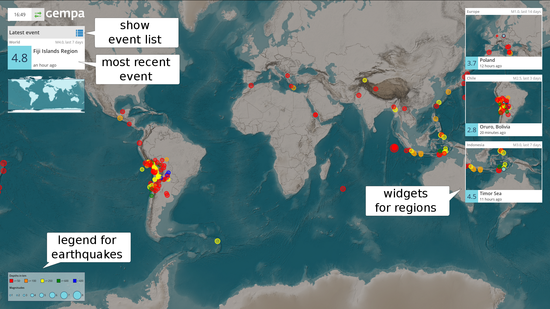
Figure 6: EQView - event map (full-screen mode). Map panels (right) show configured areas which can be selected and enlarged. Circles show event locations. The colors indicate source depth, size indicates magnitudes. Corresponding values are given in the legend (lower left). The overview map (upper left) shows the position of the central map.
Figure 7: EQView - event list (full-screen mode). Seismograms (left panel) are shown for a selected event.
StationView
StationView provides information on the state of sensor stations based on a MapView and text boxes. The information include quality control parameters, e.g. delay, latency, gaps, spikes and offset as well as current ground motion and PGD, PGV and PGA on 0.3 Hz high-pass filtered seismograms for the past 10 seconds and 5 minutes (in brackets). Clicking on a particular station shows the parameters in a inset figure.
The maps allow zooming in and out. They may be centered around the most recent event. For dense networks, stations are clustered and only the number is given at the center of the region. The region shown initially on the map can be customized, read the section Map properties.
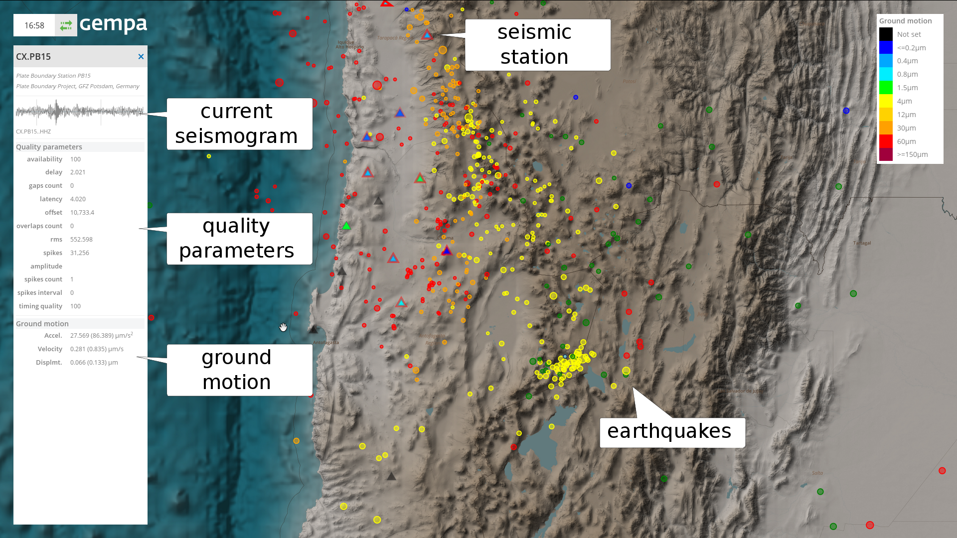
Figure 8: StationView (full-screen mode) showing the location of stations (triangles) with measured ground motion (color), active triggers (bold red circle around station), recent earthquakes (circles) within the configured area and information for one selected station (left panel).
TraceView
The TracveView allows viewing of real-time data collected on the SeisComP gaps server along with picks made on these data. The stations for which the seismograms are shown can be selected from the map of stations based on the region. The region shown initially on the map can be customized, read the section Map properties.
For showing the traces: #. Mark “Select stations” in the settings panel to the right, #. Select a region by drawing a rectangle on the map using the left mouse bottom, #. Click on “Show traces” in the settings panel to the right.
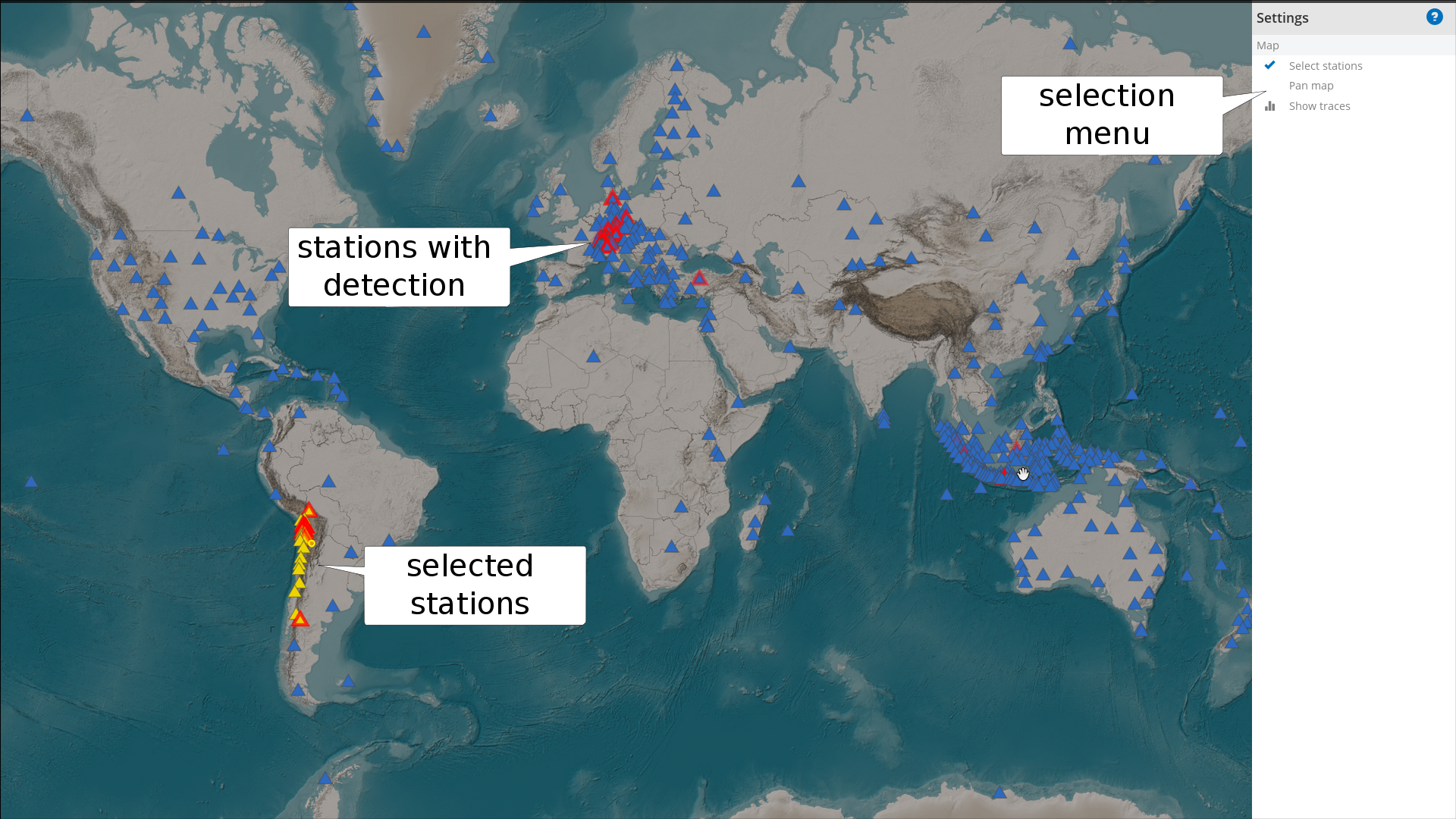
Figure 9: TraceView (full-screen mode) showing the stations (triangles) for which traces can be viewed as well as active detections (bold red triangles). The stations selected for showing traces are marked in yellow.
For adjusting seismogram filtering and zooming within in the trace window, select the parameters in the “Settings” panel. The panel can be accessed by moving the mouse arrow to the right edge of the TraceView window. The filter settings can be customized (see setup). Use the left mouse button to shift the seismograms in time.
Return to the map window by clicking on “Show map” in the “Settings” panel.
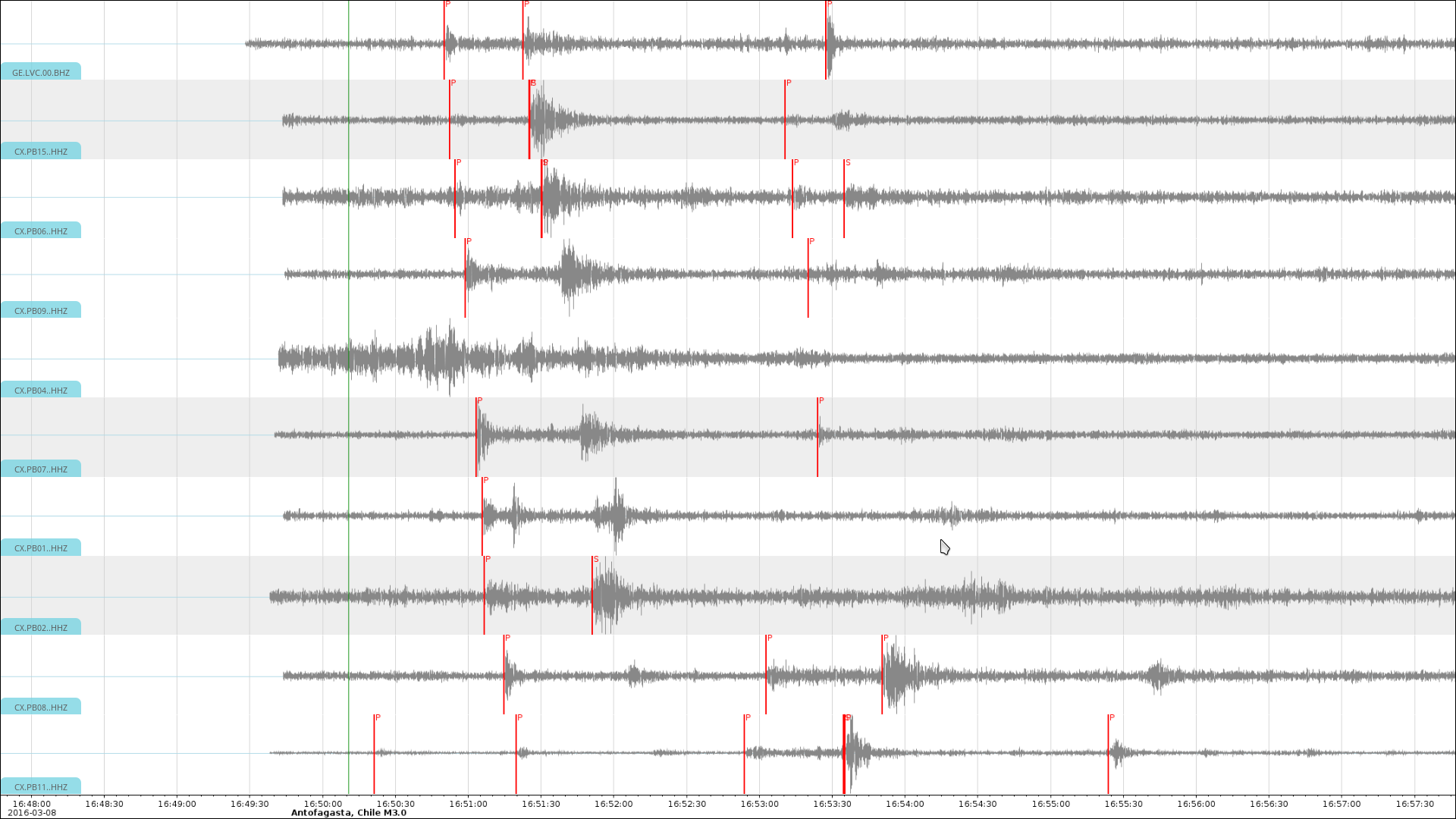
Figure 10: TraceView (full-screen mode) showing the traces for selected stations filtered in the configured frequency band.
OriginLocatorView
Use the OriginLocatorView for viewing and relocating of events. Users with granted permissions (see setup) working from allowed computers (see setup) can view the data and send back the results from data processing.
For example, everyone from any computer worldwide may have permission to view the data but only authorized staff may be permitted to commit the processing results such as picks and locations to the server SeisComP system.
Detailed help on the OriginLocatorView can be accessed through “Help” button on the upper right on all OriginLocatorView windows.
Individual events can be accessed by clicking on that particular event in the event list or in the event map. Access the event list and map by clicking on the list and map symbol on the upper right of the “Events” tab.
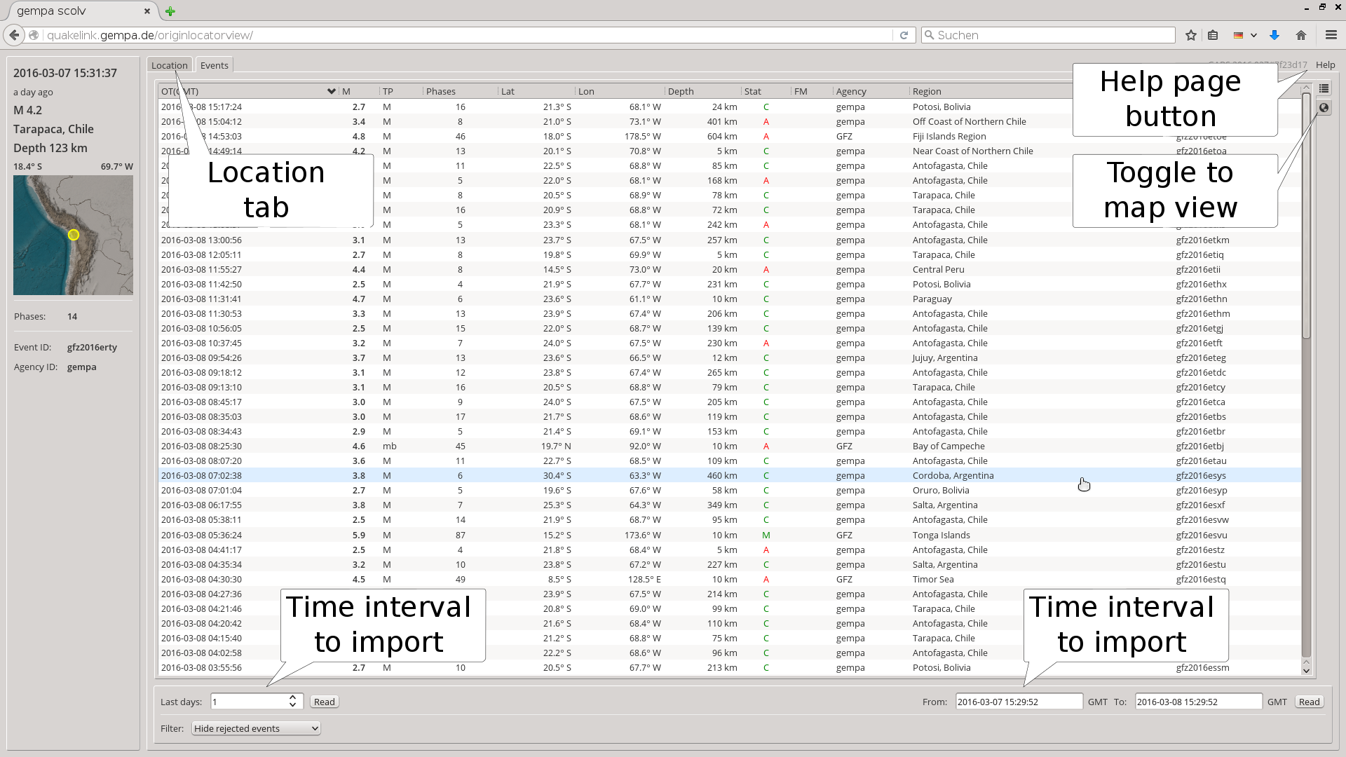
Figure 11: OriginLocatorView showing the list of events. The help module can be accessed through “Help” bottom on the upper right.
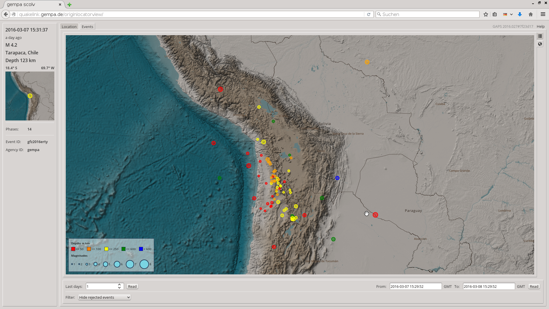
Figure 12: OriginLocatorView showing the map of events. The help module can be accessed through “Help” bottom on the upper right.
The “Locator” tab is accessed by clicking on an event in the event list or map. In the “Locator” tab the event can be relocated choosing the configured locator and locator profile. Phase picks can be selected or unselected. Clicking on “Picker” opens the picker window where existing picks of P and S phases can be reviewed and new picks can be made.
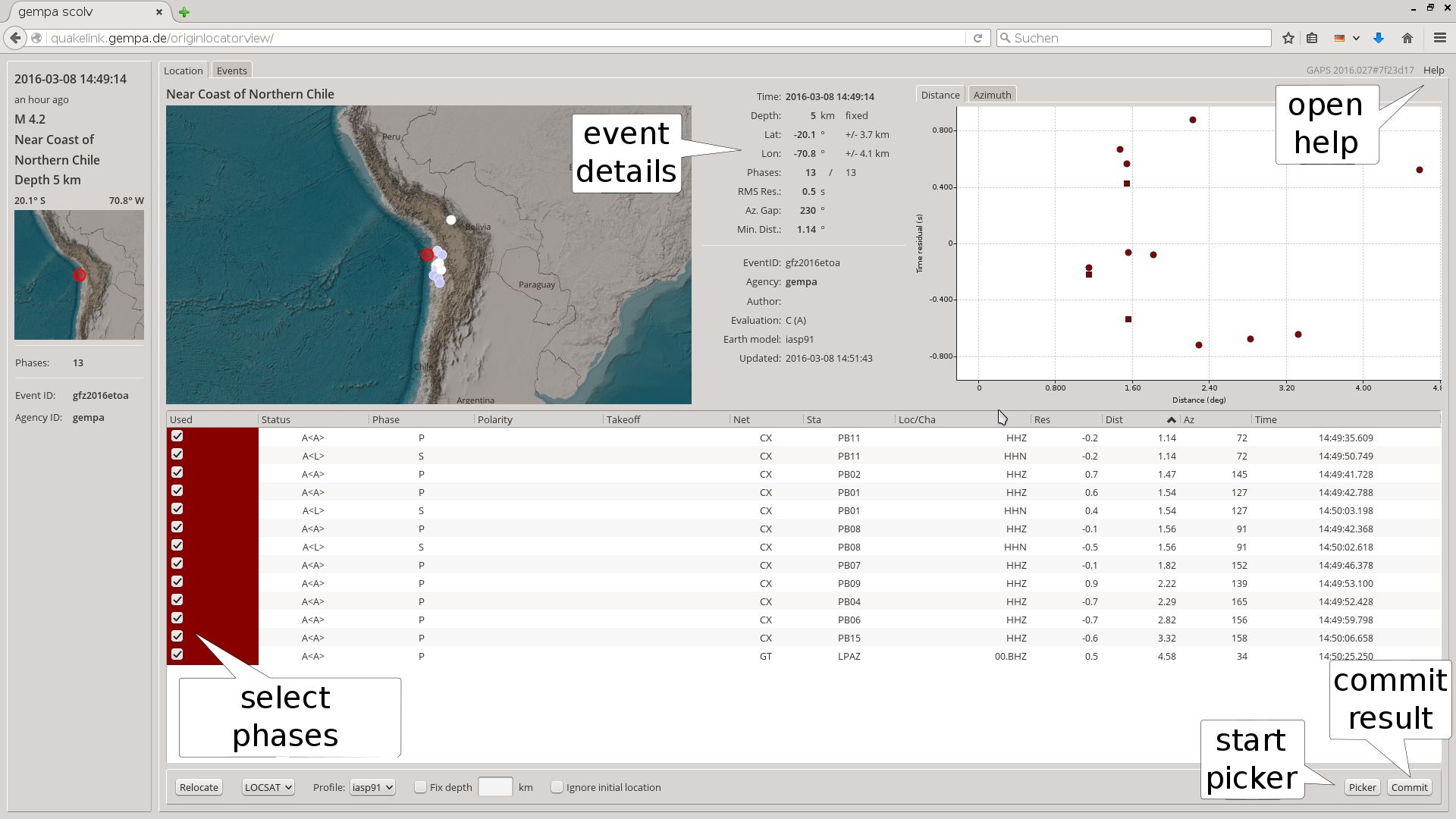
Figure 13: OriginLocatorView: Location tab.
The picks can be made in the picker window. The pick window can be accessed by clinking on the “Picker” button in the “Location” tab. In the picker window arrivals of P and S phases can be picked. Results are committed to the server by clicking on “OK”. For zooming and shifting the data in time, use the mouse wheel and the left mouse button on the time axis of the traces.
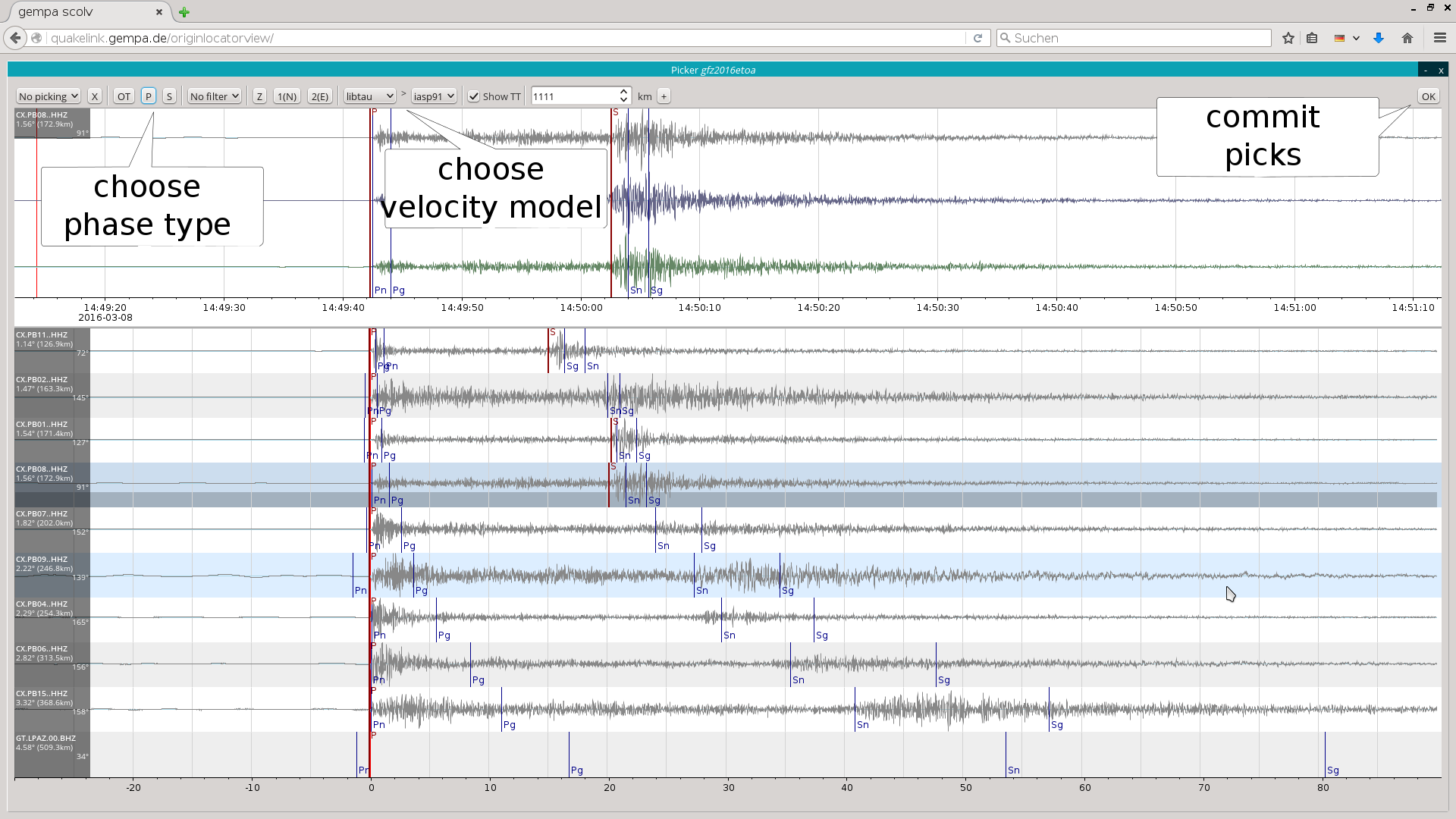
Figure 14: OriginLocatorView: picker window.
The time window parameters controlling the amount of requested data can be changed in the Setup tab. The shorter the time window the faster the data will be loaded and processed. The new parameters will be valid during the browser session. To keep the time window parameters adjust the gaps module configuration.
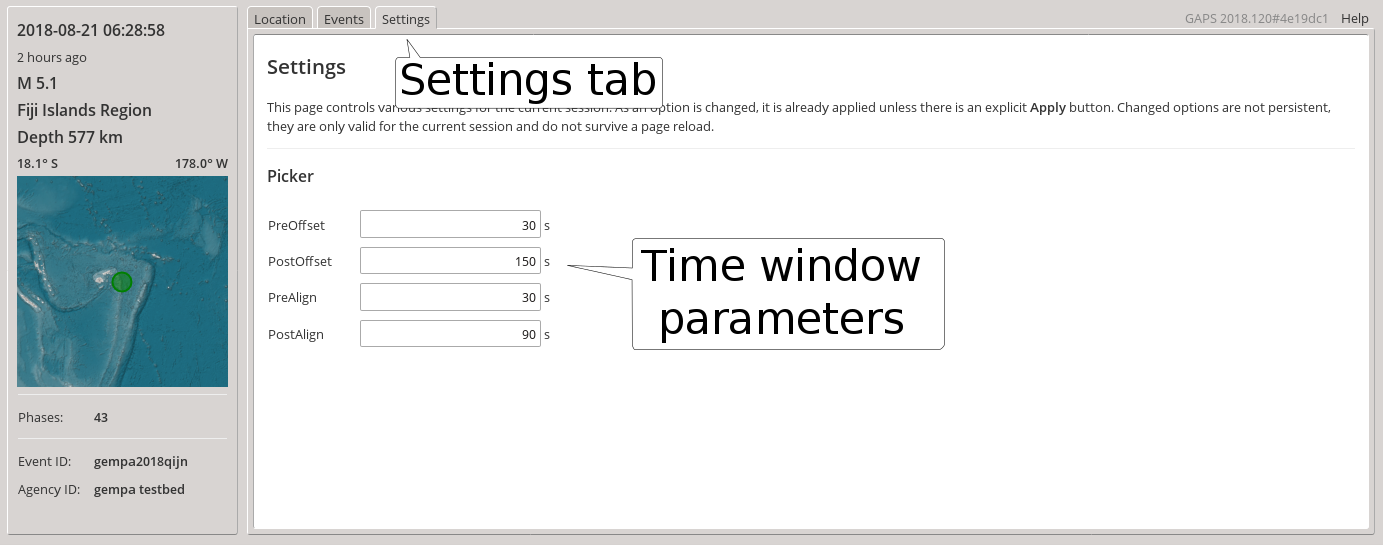
Figure 15: OriginLocatorView: setup window.
Module Configuration
etc/defaults/global.cfgetc/defaults/gaps.cfgetc/global.cfgetc/gaps.cfg~/.seiscomp/global.cfg~/.seiscomp/gaps.cfggaps inherits global options.
Note
Modules/plugins may require a license file. The default path to license
files is @DATADIR@/licenses/ which can be overridden by global
configuration of the parameter gempa.licensePath. Example:
gempa.licensePath = @CONFIGDIR@/licenses
- authbind
Default:
falseType: boolean
Allows to bind sockets to privileged ports (<1024).
- bind
Default:
127.0.0.1:8080Type: host-with-port
IP and port to bind the HTTP server to. Use 0.0.0.0 to bind to all interfaces. Either the port or the IP address may be omitted, e.g., "0.0.0.0" or ":1234". If set to an empty string the application will run without providing a HTTP server.
- sbind
Default:
127.0.0.1:-1Type: host-with-port
IP and port to bind the HTTPS server to. Use 0.0.0.0 to bind to all interfaces. Either the port or the IP address may be omitted, e.g., "0.0.0.0" or ":1234". If set to an empty string the application will run without providing a HTTPS server.
- offline
Default:
falseType: boolean
Whether to run offline (no messaging connection) or online (messaging connection). In offline mode either the database connection or the inventory and config XML files must be provided.
- computePGAVD
Default:
trueType: boolean
Enable ground motion computation. If set to false then no ground motion amplitudes are being computed.
- windowPGAVD
Default:
10Unit: s
Type: double
Time window in seconds used to compute ground motion amplitudes. The higher the time window the less amplitudes will be computed over time.
- users
Default:
@CONFIGDIR@/gaps/usersType: file
Defines the users file for access control. The user file contains one line per user where each line is of format "username:encrypted_pwd". To encrypt a password mkpasswd can be used. It is recommended to apply a strong algorithm such as sha-256 or sha-512. E.g., the command "user=sysop pw=`mkpasswd -m sha-512` && echo $user:$pw" would generate a line for the user "sysop".
- userProperties
Default:
@CONFIGDIR@/gaps/accessType: file
Defines the file used to read user properties. Each line contains the user name and a list of properties in format "username:prop1,prop2,prop3". Those properties are used to grant access to certain functionalities in gaps such as sending processing results back. There is currently only one property which is interpreted by GAPS: "staff".
- accessLog
Default:
falseType: boolean
Enables HTTP access logging to @LOGDIR@/gaps-http-access. Log files are created for 24h and kept for 7 days using log rotation.
- indexTemplate
Default:
@DATADIR@/gaps/index.csType: file
Path to the template that generated index.html.
- mediaDirectory
Default:
@DATADIR@/gaps/apps/2Type: directory
Path to media files (index.html, .css, .js, .png, …) served by GAPS.
Note: The default is valid when configuring gaps obtained with the packages gaps-frontend2 or gaps-frontend2-all. For the packages gaps-frontend or gaps-frontend-all "@DATADIR@/gaps/apps/" must be used.
- bufferSize
Default:
65536Unit: b
Type: int
Minimum buffer size in bytes per acquisition thread.
- maximumThreads
Default:
10Type: int
Maximum number of acquisition threads. This corresponds to the maximum number of parallel acquisition requests from clients.
- requestTimeout
Default:
10Unit: s
Type: int
Thread request timeout. If data of a thread has not been requested for more than n seconds the thread will be closed and finished.
- forceHTTP
Default:
falseType: boolean
Disables usage of WebSocket protocol. Useful, if traffic is tunneled through a web server that cannot handle WebSockets.
- quakelink
Default:
http://localhost:18080/events/queryType: string
The QuakeLink event request URI. This is used as a default for all web applications.
- quakelinkProxy
Default:
ql://localhost:18010Type: string
The QuakeLink proxy connection initiated by GAPS to convert and forward single events from QuakeLink to the browser. Required since QuakeLink delivers only XML format but JSON format is needed.
- tileDB
Type: path
Configures the MBTiles tile database if gaps should serve tiles itself. If mapURI is configured with a remote tile server, this is not required.
- tileLayers
Type: list:string
List of additional tile layer profiles.
Note
tileLayers.* Configuration of additional tile layers.
Note
tileLayers.$name.* $name is a placeholder for the name to be used.
- tileLayers.$name.db
Type: path
Path to MBTiles database for this tile layer.
- tileLayers.$name.levels
Type: string
Range of zoom levels this tile layer is valid for. The format is [min-level]:[max-level].
- tileLayers.$name.rects
Type: list:string
List of rectangles with respect to column / row indexes of the minimum zoom level. The format per rect is either +[min_x]+[min_y]+[max_x]+[max_y] or [column]x[rows]+[min_x]+[min_y].
- map.location
Default:
/home/data/maps/world-11/world-11.mbtilesType: file
Alternative configuration parameter for @tileDB.
- map.geoFeaturePath
Type: directory
Alternative path to geofeature files in BNA/GeoJSON format displayed on the map. The default paths are ~/.seiscomp/spatial/vector and @DATADIR@/spatial/vector. To consider a file for map display the corresponding configuration file gaps.cfg or map.cfg in the parent directory or sub-directory must contain "apps.gaps=true".
Note
HTTP.* HTTP protocol specific parameters
- HTTP.maxLineCharacters
Default:
500Type: int
Maximum number of characters of a HTTP request header line.
- SSL.certificate
Type: string
Path to SSL certificate file
- SSL.key
Type: string
Path to SSL private key file
Note
apps.* Configuration of available web applications.
- apps.mapURI
Default:
../tiles/{z}/{y}/{x}Type: string
Full URL for tiles, e.g., "http://example.com:8080/tiles/{z}/{y}/{x}". The tile server URL for all applications.
- apps.mapMaxLevel
Default:
10Type: int
Maximum zoom number for which the tiles source has available. The tiles on all zoom levels higher than mapMaxLevel will be loaded from mapMaxLevel level and auto-scaled.
- apps.mapMaxZoom
Default:
14Type: int
Maximum allowed zoom level in the interactive map.
- apps.mapShowZoomControl
Default:
falseType: boolean
Whether to show a zoom control on the map.
- apps.mapShowLegend
Default:
trueType: boolean
Show a map legend or not. Some apps might offer to toggle this setting, others not.
- apps.serverAPI
Default:
../Type: string
Path of the server API for all applications. This parameter can be overridden in each application.
- apps.serverWSAPI
Type: string
Path of the server WebSocket API for all applications. If not explicitly configured then the serverAPI path will be used.
- apps.logoPath
Default:
share/images/gempa_logo.svgType: file
Relative path to a logo (brand) image shown in web applications. Give path relative to @DATADIR@/gaps/apps. The image is scaled to the field dimension 157 px x 38 px preserving the aspect ratio.
- apps.colorMode
Default:
depthType: string
Values:
age,depth,magnitudeAvailable modes are: depth, magnitude, age
- apps.eventSymbolAnimation
Default:
toggleType: string
Values:
toggle,three-circlesAvailable animations are: toggle, three-circles
- apps.eventExternalLink
Type: string
Configures an optional external link for an event. This is only used with EQView and creates a link from the eventID at the current event info slider. The placeholder "{eventID}" is replaced with the actual eventID.
Example: "../originlocatorview/#/event/{eventID}"
- apps.colorEventsUpdateInterval
Default:
60Unit: s
Type: int
If event symbol colors are derived from the event age then the age must be recomputed at a certain interval. This number defines the interval in seconds to update the event colors. The lower the interval the more often the colors must be updated which can decrease performance.
Note
apps.mapRegion.* Configures the initial region to be shown, e.g., in TraceView and StationView.
- apps.mapRegion.minimumLatitude
Default:
-90Unit: deg
Type: double
The minimum latitude of the region.
- apps.mapRegion.minimumLongitude
Default:
-225Unit: deg
Type: double
The minimum longitude of the region.
- apps.mapRegion.maximumLatitude
Default:
90Unit: deg
Type: double
The maximum latitude of the region.
- apps.mapRegion.maximumLongitude
Default:
225Unit: deg
Type: double
The maximum longitude of the region.
- apps.eqview.geoCodeURL
Type: string
Configures the URL for geo coding. The placeholders "{lat}" and "{lon}" will be replaced by the respective earthquake location attributes.
- apps.eqview.showRegion
Default:
falseType: boolean
On startup set central map to initial region (mapRegion.*).
- apps.eqview.showRegionBounds
Default:
falseType: boolean
Shows the initial region rectangle (mapRegion.*) in the central map.
- apps.eqview.showWidgetBounds
Default:
falseType: boolean
Shows the selected widget region rectangle in the central map. This setting replaces the region rectangle (showRegionBounds) if both are set to true.
- apps.eqview.showWaveSpreading
Default:
falseType: boolean
Shows the spreading of P/S wave in the center-widget.
- apps.eqview.showWaveforms
Default:
trueType: boolean
Whether to show waveforms for the active event or not.
- apps.eqview.centerLatestEvent
Default:
trueType: boolean
Whether map will center around the latest event or not.
- apps.eqview.singleEventMode
Default:
falseType: boolean
If activated then the selected event is being shown exclusively on the map.
- apps.eqview.useUTC
Default:
falseType: boolean
Show UTC time in the front end.
- apps.eqview.externalData
Default:
trueType: boolean
If enabled then all waveforms of an event will be requested even if stations are not part of the local inventory. If disabled then only stations are allowed that are configured locally with bindings.
- apps.eqview.nearestCityMinPopulation
Default:
100000Type: int
The minimum population of a city to be taken into account as nearest city to an event.
- apps.eqview.nearestCityMaxDistance
Default:
20Unit: deg
Type: double
The maximum distance of the nearest city from an event.
- apps.eqview.showLatestMainEvent
Default:
trueType: boolean
Whether to show the latest event in the top left corner of the widget which is currently active as main widget.
- apps.eqview.showLatestOverallEvent
Default:
falseType: boolean
Whether to show the latest overall event of all widgets. It will be shown in the top right corner above the widgets.
- apps.eqview.overallTimeSpan
Default:
24Unit: hours
Type: integer
The time span for which the latest overall event will be selected.
- apps.eqview.widgets
Default:
worldType: string
Defines the available widgets. The first widget listed is taken as primary widget.
Note
apps.eqview.referencePlace.* Defines a reference place / city which is used to compute the distance and azimuth from the event shown in the event details.
- apps.eqview.referencePlace.name
Type: string
The name of the place.
- apps.eqview.referencePlace.lat
Unit: deg
Type: double
The latitude of the reference place.
- apps.eqview.referencePlace.lon
Unit: deg
Type: double
The longitude of the reference place.
Note
apps.eqview.widget.* The configured widgets.
Note
apps.eqview.widget.$name.* $name is a placeholder for the name to be used.
- apps.eqview.widget.$name.title
Type: string
The widget title as it appears in the widgets title bar.
- apps.eqview.widget.$name.minimumLatitude
Unit: deg
Type: double
The minimum latitude of the region.
- apps.eqview.widget.$name.minimumLongitude
Unit: deg
Type: double
The minimum longitude of the region.
- apps.eqview.widget.$name.maximumLatitude
Unit: deg
Type: double
The maximum latitude of the region.
- apps.eqview.widget.$name.maximumLongitude
Unit: deg
Type: double
The maximum longitude of the region.
- apps.eqview.widget.$name.eventRegion
Unit: deg
Type: region
This overrides the configured widget region and defines the region of the events to be shown. If not configured then the event region will be the same as the widget region. The format is [lat_width]x[lon_width]+[lat_min]+[lon_min] or +[lat_min]+[lon_min]+[lat_max]+[lon_max].
- apps.eqview.widget.$name.timeSpan
Unit: hours
Type: integer
The time span to be shown in hours.
- apps.eqview.widget.$name.minimumMagnitude
Type: double
The minimum magnitude to be shown.
- apps.eqview.widget.$name.maximumMagnitude
Type: double
The maximum magnitude to be shown.
- apps.eqview.widget.$name.status
Type: list:string
Event status code list that is accepted. Each item is a character (A,M,…) that maps to the type code in the QuakeLink summary format. To exclude types, a minus can be prepended to each code, e.g., "-X". That would accept all solutions except rejected. An empty list accepts everything.
- apps.eqview.widget.$name.tracePreOffset
Default:
2.0Unit: min
Type: double
The pre-offset of the traces with respect to the onset.
- apps.eqview.widget.$name.tracePostOffset
Default:
5.0Unit: min
Type: double
The post-offset of the traces with respect to the onset.
- apps.eqview.widget.$name.alignOnPredicatedArrivals
Default:
falseType: boolean
Configures whether traces are aligned on first picked onset or on theoretical arrivals.
- apps.eqview.widget.$name.showPicks
Default:
falseType: boolean
Configures if picks are shown in the waveforms.
- apps.eqview.widget.$name.visualFeedback
Default:
falseType: boolean
Whether to give visual feedback if a new event has been set as latest in the widget. If enabled then the widget shakes for a short time when the latest event updates.
- apps.eqview.widget.$name.audioFilePath
Type: file
Values:
*,*.mp3Path to an audio file played when adding a new event to the widget. The audio file is played when the event is the most recent one. For older events the audio alert is not played. Give path relative to $SEISCOMP_ROOT/share/gaps/apps, e.g., share/audio/alert.mp3. Preferred format: MP3.
- apps.traceview.cluster
Default:
trueType: boolean
Defines whether the station symbols should be clustered by default or not.
- apps.traceview.filters
Default:
"0.7Hz - 2Hz;RMHP(10)>>ITAPER(30)>>BW(3,0.7,2.0)", "1Hz - 3Hz;RMHP(5)>>ITAPER(10)>>BW(3,1,3)", "2Hz - 4Hz;RMHP(5)>>ITAPER(10)>>BW(3,2,4)", "4Hz - 8Hz;RMHP(5)>>ITAPER(10)>>BW(3,4,8)", "HP 3 Hz;RMHP(1)>>ITAPER(2)>>BW_HP(3,3)"Type: list:string
The list of filters available in TraceView, format per item is "name;filter-string".
- apps.traceview.timeSpan
Default:
600Unit: s
Type: double
Timespan for trace display. The default is 600 s (10 min).
- apps.traceview.utc
Default:
falseType: boolean
Whether to show trace times in UTC or local time.
- apps.mapview.mode
Default:
delayType: string
Values:
delay,latency,groundmotionDefines the default MapView mode that is used to color the station symbols. Valid values are "delay", "latency" and "groundmotion".
- apps.mapview.cluster
Default:
trueType: boolean
Defines whether the station symbols should be clustered by default or not.
- apps.mapview.eventTimeSpan
Default:
168Unit: hours
Type: integer
The events time span to be shown in hours.
- apps.mapview.customStationLink
Type: string
Defines an additional link that is rendered on the station detail page. It supports two placeholders: ${net} and ${sta} which are replaced during runtime.
- apps.mapview.customStationLinkName
Type: string
The name as displayed on the station panel for the custom station link.
- apps.mapview.fetchGeoIP
Default:
falseType: boolean
If enabled then the map will be centered around the clients geolocation (fetched via web service from www.geoplugin.net).
- apps.scolv.loadEventDB
Default:
1Unit: days
Type: double
Number of days to preload if scolv is started.
- apps.scolv.useUTC
Default:
trueType: boolean
Show UTC time in the frontend.
- apps.scolv.distInKM
Default:
falseType: boolean
Show distances in km instead of degree.
- apps.scolv.magnitudes
Default:
MLv,mb,mB,MwpType: list:string
List of magnitude types to be calculated when computing magnitudes. This list can be altered interactively so it reflects only the default unless computeMagnitudesSilently is set to true. The configured types should include all types which are also computed by scmag in order to allow their processing in scolv. Otherwise scmag may add magnitudes to origins without interaction in scolv.
- apps.scolv.ttt
Default:
LOCSAT,libtauType: list:string
The list of active travel time table interfaces.
- apps.scolv.commonEventTypes
Type: list:string
A list of event types which are commonly set. This defines a priority list which will be displayed on top of the event type selection menu. Additionally the remaining (non-prioritized) types are displayed below a separator. The order is preserved in the drop-down list of the "Commit with options" dialog.
- apps.scolv.commonEventTypeCertainties
Type: list:string
A list of event type certainties which are commonly set. This defines a priority list which will be displayed on top of the event type certainty selection menu. Additionally the remaining (non-prioritized) types are displayed below a separator. The order is preserved in the drop-down list of the "Commit with options" dialog.
- apps.scolv.locator.interface
Default:
LOCSATType: string
Values:
FixedHypocenter,Hypo71,LocExt,LocRouter,LOCSAT,NonLinLoc,StdLocThe default locator interface to use.
- apps.scolv.locator.defaultProfile
Type: string
The default locator profile to use.
- apps.scolv.picker.filters
Default:
"@0.7Hz - 2Hz;RMHP(10)>>ITAPER(30)>>BW(3,0.7,2.0)", "1Hz - 3Hz;RMHP(5)>>ITAPER(10)>>BW(3,1,3)", "2Hz - 4Hz;RMHP(5)>>ITAPER(10)>>BW(3,2,4)", "4Hz - 8Hz;RMHP(5)>>ITAPER(10)>>BW(3,4,8)", "HP 3 Hz;RMHP(1)>>ITAPER(2)>>BW_HP(3,3)"Type: list:string
List of filters available in the picker. If @ is prepended to the name of the filter it will be selected as default filter. The format of each entry is "name;definition", e.g., "BP 0.7 - 2 Hz 3rd order;BW(3,0.7,2)"
- apps.scolv.picker.phases
Default:
P,Pn,Pg,pP,S,Sg,sPType: list:string
List of phases enabled for picking.
- apps.scolv.picker.preOffset
Default:
300Unit: s
Type: double
Begin of time window before origin time to load waveforms when the picker is opened.
- apps.scolv.picker.postOffset
Default:
600Unit: s
Type: double
End of time window after origin time to load waveforms when the picker is opened.
- apps.scolv.picker.preAlign
Default:
30Unit: s
Type: double
The default time window shown before the trace alignment. Alignment is set interactively by origin time or P- or S-phase arrival.
- apps.scolv.picker.postAlign
Default:
90Unit: s
Type: double
The default time window shown after the trace alignment. Alignment is set interactively by origin time or P- or S-phase arrival.
- apps.scolv.picker.loadAllComponents
Default:
falseType: boolean
Load all three components by default. If disabled, additional components are fetched upon request.
Note
apps.scolv.ttt.* Travel time table related configuration. Travel time tables can be added via plugins. Built-in interfaces are libtau and LOCSAT. For each activated interface a list of supported models must be provided.
Note
apps.scolv.ttt.$name.* $name is a placeholder for the name to be used.
- apps.scolv.ttt.$name.models
Type: list:string
The list of supported model names per interface.
- processors.events
Type: list:string
Activate event processor profiles, see GAPSEventProcessorProfile.
Note
processors.events.* Configures one or more event processors which are executed at server-side and displayed client-side in EQView after selecting a set of events with ctrl + left mouse key.
Note
processors.events.$name.* $name is a placeholder for the name to be used.
- processors.events.$name.title
Type: string
The title of the processor shown at the client in the processor selection popup and as header in the output window.
- processors.events.$name.script
Type: path
Path to the script to be called when the processor has been triggered. This script must be executable, take the CSV file from stdin and print the result image to stdout. The input CSV file contains the following columns separated by semicolon:
* eventID
* OT
* lat
* lon
* depth in km
* mag
* agency
* status
* phases
* region
* fm.strike
* fm.dip
* fm.rake
* fm.depth
* fm.mag
Only results from script runs with exit code zero are taken into account.
- processors.events.$name.type
Type: string
Values:
html,json,png,svg,txt,xmlThe type of the returned product. Valid values are "txt", "html", "json", "png", "jpeg", "svg", "xml".
- processors.events.$name.authorize
Default:
falseType: boolean
If enabled then authorization will be requested for this script from the browser. That means that a user has to authenticate first before the result will be displayed. Authorization is granted if an authenticated user is staff member.
- scheme.colors.stationTypes
Default:
BB:008000,SM:0000FF,SP:40E0D0Type: gradient
Configure the station colors of a particular type. The type is read from Station.type of the inventory. If unset, the parent Network.type is used.
- scheme.colors.originSymbol.age.gradient
Default:
0:ff0000:"1 hour",3600:ff8000:"1 day",86400:ffff00:"1 week",604800:ffffff:"1 month",2592000:808080:"older"Type: gradient
Configure the event age color gradient. Only applied if color mode is "magnitude".
- scheme.colors.originSymbol.magnitude.gradient
Default:
1:83c3f0:"< 2",2:4285af,3:6ab69c,4:a3cf9a,5:eccf8c,6:e6ae6e,7:db765a,8:c05065Type: gradient
Configure the event magnitude color gradient. The colors are applied if color mode is "magnitude". Furthermore the color gradient node values are used as values of the magnitude legend.
- scheme.colors.gm.gradient
Type: gradient
Configure the ground motion color gradient. Only applied if color mode is "groundmotion".
- scheme.colors.gm.unit
Default:
um/sType: string
The ground motion unit of the parameters sent to the client.
- scheme.colors.qc.gradient
Type: gradient
Configure the latency and delay color gradient. Only applied if color mode is "delay" or "latency".
- scheme.map.stationShape
Default:
hexagonType: string
Values:
diamond,hexagon,triangleThe station symbol shape. Valid values are: hexagon, triangle and diamond.
- scheme.map.stationBorder
Default:
3Unit: px
Type: integer
The width in pixels of the station symbol frame.
Bindings Parameters
- enable
Default:
trueType: boolean
Enable/disable the usage of a station with web apps.
Command-Line Options
gaps [options]
Generic
- -h, --help
Show help message.
- -V, --version
Show version information.
- --config-file file
The alternative module configuration file. When this option is used, the module configuration is only read from the given file and no other configuration stage is considered. Therefore, all configuration including the definition of plugins must be contained in that file or given along with other command-line options such as --plugins.
- --plugins arg
Load given plugins.
- -D, --daemon
Run as daemon. This means the application will fork itself and doesn’t need to be started with &.
Verbosity
- --verbosity arg
Verbosity level [0..4]. 0:quiet, 1:error, 2:warning, 3:info, 4:debug.
- -v, --v
Increase verbosity level (may be repeated, e.g., -vv).
- -q, --quiet
Quiet mode: no logging output.
- --component arg
Limit the logging to a certain component. This option can be given more than once.
- -s, --syslog
Use syslog logging backend. The output usually goes to /var/lib/messages.
- -l, --lockfile arg
Path to lock file.
- --console arg
Send log output to stdout.
- --debug
Execute in debug mode. Equivalent to --verbosity=4 --console=1 .
- --log-file arg
Use alternative log file.
Database
- --db-driver-list
List all supported database drivers.
- -d, --database arg
The database connection string, format: service://user:pwd@host/database. "service" is the name of the database driver which can be queried with "--db-driver-list".
- --inventory-db arg
Load the inventory from the given database or file, format: [service://]location .
- --config-db arg
Load the configuration from the given database or file, format: [service://]location .
- --config-module arg
The config module to use.
Messaging
- -u, --user arg
Overrides configuration parameter
connection.username.
- -H, --host arg
Overrides configuration parameter
connection.server.
- -t, --timeout arg
Overrides configuration parameter
connection.timeout.
- -g, --primary-group arg
Overrides configuration parameter
connection.primaryGroup.
- -S, --subscribe-group arg
A group to subscribe to. This option can be given more than once.
- --start-stop-msg arg
Default:
0Set sending of a start and a stop message.
Records
- --record-driver-list
List all supported record stream drivers.
- -I, --record-url arg
The RecordStream source URL. Format: [service://]location[#type]. "service" is the name of the RecordStream driver which can be queried with "--record-driver-list". If "service" is not given, "file://" is used and simply the name of a miniSEED file can be given.
- --record-file arg
Specify a file as record source.
- --record-type arg
Specify a type for the records being read.
Mode
- --offline
Do not connect to a messaging server. The database connection must be provided explicitly.
Users
- --list-users
List available users.
- --list-props uid
List properties for a user.
- --verify-user uid
Asks for a password of the user and checks if the password is correct. The exit code reflects the verification state.